


Weather overview and short-term outlook to Wednesday 18 March 20

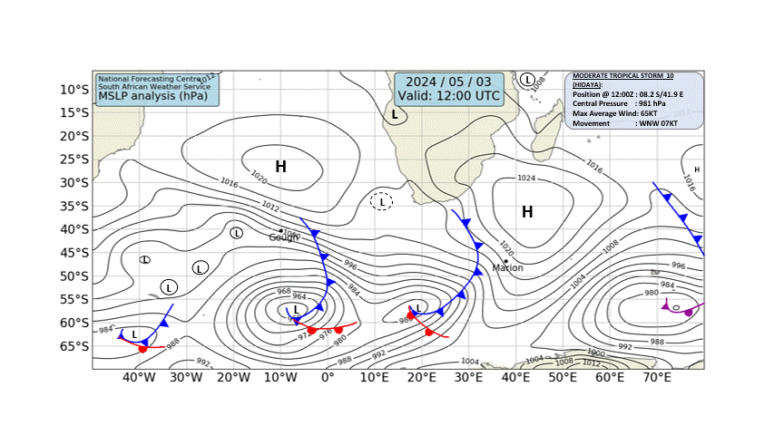
Visual: Synoptic map of surface pressures as on Friday 13 March
Source: South African Weather Service, www.weathersa.co.za/images/data/specialised/ma_sy.gif.
Recent Developments
Friday morning’s synoptic map shows such regular features, it serves well as a basis to discuss the weather progression of this week. There are only two slight anomalies namely the positions of both the South Atlantic high pressure cell (HSA) and the southern Indian high (HSI).
The South Atlantic high is somewhat on the weak side, reading only 1020 mB in the core which is displaced to the north by a only a small margin. Note that the core is very large, covering an area of at least 2000 km from west to east. This indicates very quiet and mild conditions, signalling that its impact on the continent in about four days will be limited. However, at this time of the season, the core would have been expected much further south.
The southern Indian high is displaced much further to the south than what is normal, and it is exceptionally strong for summer, reading 1032 mB. This indicates that the impact from the east will endure longer than the normal two or three days.
The continental high (HC) is the important feature to watch. A lot depends on how long it stays put as it drives the anti-cyclonic circulation that covers a large part of the sub-continent. As it ridges further inland, it has the potential to keep the mid-level trough across Namibia in its position for longer. The red arrows indicate the airflow around the ridge to a point over the Karoo where it splits, a part following the isobar contour to the north, and another part moving to the cut-off low (blue circle) just offshore Port Elizabeth in South Africa.
The row of short yellow arrows indicate the onshore airflow from the outer rim of the South Atlantic high. This airflow opposes the airflow from the north but with such a weak South Atlantic high, the local impact is minimal. It is also mostly restricted to the surface level.
The fat pink arrow indicates the general direction of airflow ahead of the cold front. Once the cold front has passed the southern Cape, the airflow will revert to the more customary south to north flow.
The two blue circles just north-east of Madagascar are important weather features for the entire southern Africa. Their strength and direction determine to a large extent the amount of moisture that is picked up by the northern rim of the southern Indian high and advected into the sub-continent’s interior.
On the Radar
For the weekend, it is only the northern areas with a reasonable chance for light rain. But since the mid-level trough is in place and the airflow over northern and central Namibia is predominantly from the north, moisture will continue to enter Namibian airspace, even into the southern regions but only east of the escarpment. This will be visible in the form of scattered cloud but no rainfall is expected in the southern half.
By Monday, the mid-level trough is expected to have shifted to the west, entering Namibia in the Kunene region. Consequently, rainfall prospects also shift to the north-west but showers will be brief and light. These conditions should extend south to about Kamanjab.
By Tuesday, the trough has become more prominent but is expected to remain over the northern Namib before cutting across the interior into southern Botswana. Similar to the weekend, widespread cloud formation will be visible in the interior but it is only the active zone as defined by the trough where there is a reasonable chance for precipitation. Rainfall prospects will also be marginally positive in Babwatwa and the Caprivi.
The trough stays in situ for at least another day (Wednesday) crossing the northern Namib from north to south, then cutting across the interior into southern Botswana.
Although the presence of the trough improves the rainfall prospects for the north-west, the central interior and the eastern part of the Hardap region, the forecasts expect only limited rain with falls typically not exceeding 5mm.


