28 March 2014
![]() What Happened?
What Happened?
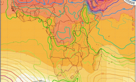
Conditions this week were somewhat anomalous. A prominent high pressure cell developed south-east of South Africa with its core some 2000 km south of Madagascar. This may seem very far from distant and dry Namibia but this system was so powerfull and extensive, its influence was seen thousands of kilometres to the north and the west. It was the engine that drove the intra-continental trough (broad low-pressure band) all the way from central Angola to far south of the continent.
We happened to lie in the path of this major through.
At the northern rim of the high pressure cell, an area of marked low-pressure circulation formed over the northern bits of the Mozambican channel. This provided the uptake of moisture, driven by the high pressure engine thousands of kilometres to the south. Massive amounts of Indian Ocean moisture was circulated in all levels from the surface to the troposphere across Tanzania, the DRC, Zambia and Angola.
See the high pressure system as a huge rotating wheel thousands of kilometres across. At its top end, the wheel connects with the tropical low-pressure area, advecting all this moist air in a very large circle across the entire sub-continent. Namibia is on the western side of this wheel hence the airflow is from the north, and the source of moisture is the tropics in Zambia, the DRC and Angola. The result is continuous rain from a very low cloud base over a very wide area, developing from north (Angola) to south (South Africa) with us in the lane.
Keeping the trough over Namibia for about three days was effected by the stationary nature of the (eastern) high pressure cell’s core, and its intensity. At some point, early in the week, the barometric pressure in the core reached 1032 mB. This is indicative of a very prominent high pressure cell and it explains why its influence stretched over so many thousands of kilometres. At that point the comparative reading of the South Atlantic High Pressure Cell, was only 1028 mB – sufficiently cold and dense, but not strong enough to make the cell south of Madagascar budge. Its intensity kept the eastern cell in position much longer than usual, creating good conditions for advection of moisture across Namibia over a number of days. The recorded rainfall (on page 3) tells the rest of the story.
Meanwhile, the South Atlantic High Pressure Cell edged closer to the continent, clearing our skies on Wednesday, and displacing the eastern cell, thus shifting the large area of circulation to the east. By the end of the week, the trough has become only a faint line on satellite images, having lost much of its strength compared to earlier in the week when, for all practical purposes, it has covered some 90% of the surface area of Namibia.
What’s coming?
The South Atlantic High made landfall on Wednesday. The wind direction backed to the customary south-west. Over this weekend, the wind will gradually, from Saturday to Sunday veer to south-east before becoming a standard east wind for the early part of next week. Once the shifting high pressure cell spills over eastern South Africa, it again becomes the engine driving the zonal (east to west) flow from the Indian Ocean across central Africa. While the steady loss in temperature as the season changes, works against massive moisture advection, conditions still remain favourable for light, late summer rain up until the middle of April.