Weather 04 September 2015
 What Happened
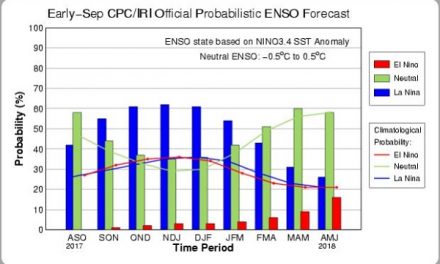
A full-blown El Nino event now rages in the east Pacific. Technically this is defined as five successive three-month intervals during which the surface temperature of the equatorial Pacific has departed more than 2oC above the mean.
In short the water in the equatorial Pacific is warmer by about 2,5oC closer to the Americas, and between 1.5oC and 2oC closer to Indonesia. At deeper levels, up to 500 m depth, the anomaly is even bigger now exceeding 5oC above the mean over a very large area about 1000 km offshore Panama. Further north off the coast of California, another very large swathe of anomalously warm surface water has been sedentary for the past two seasons. This anomaly extends along the US coastline up to Washington State (Seattle). However, closer to Equador, it seems as if the El Nino event has peaked in July and is now reverting to normal. The question for Namibia is, how fast this reverting process will happen? It could be six months, it could be two years. At the beginning of the week, the synoptic map showed a typical late-winter stance with one exception, the presence of a strong vortex south of Cape Agulhas. On either side of this depression lay the familiar South Atlantic high pressure cell, some distance offshore, and the southern Indian high pressure cell, south-east of Madagascar. The latter has been in situ for over a week and produced the low-pressure trough in the mid levels around 25,000 feet which crossed Namibia during the previous weekend. By Thursday, the South Atlantic high had progressed around the southern limits of the continent covering the southern Cape, eastern Cape, Kwazulu Natal, and even into Swaziland. It also grew in intensity reading some 1032 mB by week’s end. It brought winter back to South Africa with a vengeance and Namibia did not escape the cold intrusion. However, since solar irradiation has now increased to 11 hours and 45 minutes, the cold night effect of this high is quickly replaced in the mornings by warmer air from the north, leading to mild days in the Karas and Hardap regions with warm afternoons. Further north, the effect was less marked being displaced by a strong easterly airflow. Along the Angolan and Zambian borders, the airflow was predominantly north, the barometric pressure was low and consequently the days were hot. As the high moved across the Karas region towards Botswana, a surface trough started developing at the Kunene mouth, migrating towards the south along the coastal plain. With higher pressure over Botswana and the eastern half of Namibia, later in the week, and a weak trough below the escarpment, it lead to windy conditions especially at night when the sun’s warming effect was gone. The closer to the escarpment, the more pronounced the wind was. During this transition period from winter to early summer, this week’s events provide a strong hint that the two high pressure cells (Atlantic and Indian) will remain dominant and will keep their conventional positions or be slightly displaced to the north. The area to watch is the typical low-pressure band that develops between the two highs crossing the subcontinent from west to east. The anomalous feature, the persistent strong vortices that developed south of the Cape and dissipate the approaching cold fronts, is the synoptic element with the biggest potential to disrupt the expected (forecast) scene.
What’s Coming
While Friday has still seen some easterly airflow from the high pressure over South Africa, by Saturday, the high has weakened and migrated further east with only its outer rim still covering the South African highveld. The (low pressure) trough that entered Namibia from the Kunene river earlier in the week continues to move south along the coastal plain. Along the Angolan border it expands bringing more hot days to Owambo and the Kavangoes. By Saturday evening, this low pressure area has developed into a proper trough covering Namibia from north to south. It will bring dusty and hazy conditions to most of the country. By Monday however, the synoptic pattern is back to the typical late-winter stance but the new vortex south of the Cape is expected to be considerably stronger than this week’s vortex. Being at the southern end of the continental trough, this vortex helps drive the airflow from north to south, bringing hot conditions to Kavango East and the Caprivi, and we may even see the first early rains in these two regions.


