


Weather overview and short-term outlook to Wednesday 15 September 2021
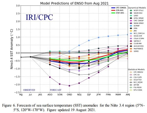
Visual: Seasonal outlook of the El Nino Southern Oscillation in the equatorial Pacific.
Source: Climate Prediction Centre in the National Oceanic and Atmospheric Agency of the US Government. www.cpc.ncep.noaa.gov/products/analysis_monitoring/enso_advisory/ensodisc.pdf
Recent Developments
A broad consensus is gradually emerging among regional forecasters that rainfall expectations for the upcoming summer are positive but there is little agreement on exactly how the successive 3-month seasons will pan out.
Despite all claims to the contrary, Namibia has experienced a fairly regular winter, snow and all. Snow in the south is not that uncommon, especially on the escarpment in the Aus district. The same applies for rain in the south where, on average, between 15 and 20 mm precipitation is measured annually. It has to be pointed out however, that the south, typical for any arid area, can be very erratic with one or more years with zero rainfall, and then suddenly a “good” year like this year.
Perhaps the best indication of a regular winter is the way it transitions into early summer. It is a feature of this transition that it is abrupt, literally switching from winter to summer in a week. This is what has happened over the past decad and with so much moisture at the 500 mB level, it is not unreasonable to expect light showers before the end of September.
Again, this is fairly normal for most of the interior and indeed, according to satellite imagery, there are many place in the north-eastern quadrant, i,e,the former Hereroland East, Bushmanland and Kaudum where some rain fell this week. The only problem is finding a tangible record of this water since very large areas are sparsely populated without dependable weather stations of any kind.
To appreciate the practical limitations of observation in the bush, consider that it may not rain anything at all in Tsumkwe but only 10 km away, there may be a considerable shower, only it does not show up in the stats because it was never recorded. From the satellite’s watching eyes, however, it cannot escape.
The season that we are now entering is usually marked by two features: – bushfires and virga rain. The horrible reality of bushfires have manifested itself only too dearly over the recent past while virga rain requires clouds (only starting to appear now) and unstable conditions in the middle and upper layers of the atmosphere. Virga rain is when it rains visibly hard immediately below the clouds but not a drop reaches the surface. (Virga is Latin for old man’s beard).
On the global front, it is noteworthy that the El Nino Southern Oscillation in the equatorial Pacific Ocean has already peaked (a very weak one) and seems to be returning to neutral/negative. (See this week’s visual) When sea surface temperatures start cooling in the Pacific even before it has developed into a proper El Nino, the chances are above average that it will lead to a strong La Nina in about four months from now, which takes us smack into the middle of the main summer rainfall season.
On the Radar
Condition throughout the entire country will carry on mostly unchanged from this week, for the duration of the weekend.
By Sunday evening, the next approaching South Atlantic high pressure cell is approaching Oranjemund but there is a chance that it will not make actual landfall since the anti-cyclonic circulation over the sub-continent’s interior is too strong.
Nevertheless, the South Atlantic high is a powerful animal, bringing cooler and very windy conditions to the Karas region on Monday and Tuesday.
A growing cyclonic cell behind the front has the ability to develop into a full intrusion in the south, again bringing some light rain in the convergence zone. This is only expected by next week Thursday or Friday and the forecast window is too far out to provide a reliable outlook.
The rest of the country will be unaffected, daily getting warmer with hot to very hot conditions north and north-east of Etosha.


