


The Week’s Weather up to Friday 24 November. Five-day outlook to Wednesday 29 November 2017
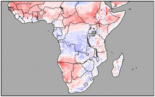
Map: Smoothed temperature anomalies for the 8-day period from Friday 24 November to Saturday 02 December 2017. Normal temperature is based on observations from 1901 to 2000.
Source: US National Centre for Environmental Prediction, www.wxmaps.org/outlooks
The temperature anomaly map is an aggregate of expected daily conditions measured against historical values. As such it is not indicative of the temperature at any given time on any given day, but it shows the departure from the average if all the readings were to be smoothed over the 8-day period.
It has to be read in conjunction with the surface pressure map and the lateral air movement map for 18,000 feet elevation.
What it shows clearly is that, on average, temperatures across Namibia will be higher than usual by between 2°C and 8°C. The first signs of this development became noticeable this week when afternoon temperatures over the central plateau consistently measured around 34°C late in the afternoon.
The importance of next week’s temperature map is that it implies surface conditions will be completely opposite compared to last week, and that this week was a transition phase.
As was indicated in the previous weather column, the unexpected cold intrusion was the result of the immense power and extent of the South Atlantic high pressure cell. During this week that cell migrated around the Cape Province but mostly stayed offshore. The effect of its outer rim was still felt in the Karas Region where both Tuesday and Wednesday mornings were cool.
This intrusion was only very brief and by Wednesday afternoon conditions have normalised and the expected early summer heat was felt in the afternoons across the entire country. This happened as the influence of the high receded, dispelled in part by the intrusion of warmer air from the north.
Generally, barometric pressure were lower for most of the country, especially in the second half of the week, and as the map indicates, they will be even lower next week. This means the local weather has transitioned from a stance controlled by high pressure on the surface (ground level) to one where low pressure is present over the entire country above the escarpment. In the Kunene region, this area of lower pressure extended right up to the ocean.
The lower surface pressures are not confined to Namibia. Southern Angola, Western Zambia, western Botswana and the Karoo in South Africa, are all affected by the same conditions. These conditions will continue into next week, as shown by the map.
Why then the higher than average temperatures?
Warmer air is less dense than cold air so it has the tendency to rise. If it were not so, vultures could not fly. This rising air elevates the entire atmosphere driving the 200 mB surface to as high as 45,000 feet. This is amplified by solar energy. However, once the son is past its zenith, the system gradually loses energy and starts to sink. It is this massively deep column of sinking air that compresses and releases energy and that is what drives the temperature up. It is called diabatic compression.
Supported by a prominent airflow from the north and a relatively thick atmosphere, conditions are set up to create areas of unstable air which is what is required for convection. The beginning of this process is what controlled local weather for the second half of this week.
What’s Coming
The core of the South Atlantic high sits about 1000 km offshore west of Cape Town. It remains there. It will remain there for the next eight days, giving ample opportunity for the low pressure control over Namibia to develop further.
During the weekend, the South Atlantic high sends a protrusion around the Cape again but the impact remains restricted to South Africa south of the Orange River.
In Namibia, the local stance is dominated by low pressure conditions. Its extent remains more or less the same as described in the analysis above, meaning it will be hot to very hot above the escarpment, and blisteringly hot in the Kunene region where the low pressure is most dominant.
Cloud cover will be restricted to the northern half of the country, spreading over a wider area during next week. By Wednesday a medium strength mid-level trough runs from Ohangwena in the north, through Kavango West, Otjozondjupa and Omaheke, with a possibility of reaching Mata Mata in the Kalahari.
Rainfall is indicated only for the north-eastern quadrant, and only from Tuesday onwards.


