


Weather overview and short-term outlook to Wednesday 05 May 2021
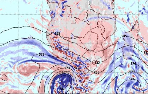
Visual: Expected mid-level conditions for Wednesday 05 May.
Source: GrADS/COLA, George Mason University. http://www.wxmaps.org/fcst.php .
Recent Developments
The visual shows an interesting forecast of mid-level conditions some five days from Friday 30 April. This is like a synoptic map for the 500 mB level, about 18,000 feet above sea level.
The visual, although only a forecast at this point, is an excellent representation of the effect of the leading rim of the next approaching South Atlantic high pressure cell, augmented in this case by the strong possibility of a so-called cut-off low forming over the Western Cape. This is the blue circular area covering the Cape.
These expected conditions are a continuation of conditions of the past week with the only exception the position of the South Atlantic high’s core. As winter approaches the core gradually shifts north by between 600 and 800 kilometres although it must be stated that the cores of two successive South Atlantic highs are never exactly on the same latitude.
What we have seen since the weekend of 17 April is the influence of the mid-level trough that regularly runs from Angola through Namibia into South Africa. This trough is a typical summer feature but during the summer winter transition in late April to middle May, the trough encounters the South Atlantic high, usually somewhere in Namibian airspace, and this may lead to spectacular late-season showers, as we experienced.
The South Atlantic high is strongest on the surface but because it is such a vast, powerful system, it also exerts an influence right up to the alto levels. Still, it remains cold and dense. The trough originates in Angola so its air is warmer and buoyant. When the trough runs into the high, it is pushed higher increasing convection and sometimes producing thunder showers that are quite surprising, both in intensity and extent.
On the Radar
As explained in the previous overview, a cut-off low over the Cape or just offshore South Africa’s west coast, is in fact a huge weather pump. This can also be seen in the visual.
On its eastern side, it draws in warm, tropical air via the mid-level trough which is then circulated clockwise into and over the South Atlantic high. On the low’s northern fringe, a convergence zone usually forms and this is where rainfall activity occurs. In the visual it is the dotted blue and mauve band running through central Namibia.
This gives us some hope of late, light showers starting on Sunday and covering the central and southern regions. By Monday the bias has shifted to the west and there is a limited possibility of some rain over the Namib and the adjacent escarpment. These conditions are expected to cover most of the desert except the southern Sperrgebiet.
The approaching South Atlantic high carries the first signal of winter and during the weekend colder conditions will set in over the Sperrgebiet, moving to the rest of the Karas region by Monday, and then shifting to the eastern part of the Hardap region. By Tuesday the nights in the south and eastern parts along the Botswana and South African borders will be quite cold.
The cloudy conditions that will be present over the country’s western half is expected to be most prominent by Wednesday.


