


11 July 2014
![]() What Happened?
What Happened?
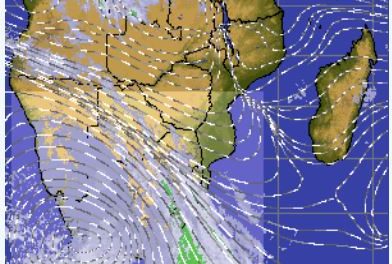
A strong anti-cyclonic circulation in the alto levels with its core situated over Western Zambia, created equally strong jet stream over Namibia blowing from west to east. Airline pilots flying the Johannesburg Windhoek route are only too familiar with this phenomenon. Flying west, against the jet stream, can easily add up to twenty minutes to the normal flying time. Flying east, riding on the jet stream’s wings, flying time can be reduced by as much as half an hour. This upper air anti-cyclonic circulation is the alto extension of the high pressure cell on the surface which covered the entire subcontinent from the weekend, throughout the week, and was lingering over the South African highveld by the end of this week. Although the direction of the circulation is induced and determined by the anti-cyclonic circulation of the high on the surface, at those lofty levels, it is no longer a high pressure system, but displays all the elements of a typical low pressure system, except that it rotates in the opposite direction. What is does is to dissipate the intensity of the surface high pressure leading to milder days when more severe cold is expected. At night, with terrestrial radiation at its maximum and zero solar radiation, the high pressure system quickly dominates conditions on the surface. This is the reason why the temperature drops so dramatically when the son sets. But an hour after sunrise, solar radiation warms the surface, a measure of convections follows, and barometers across the country indicate that the pressure is slowly dropping. The result is a pleasantly mild to warm day. This was displayed on every day this week.
The anti-cyclonic circulation is not without effect on the surface. Starting on Monday, as the high pressure cell held sway over the interior, an area of lower pressure developed at the Kunene mouth. This is a very typical occurrence in the wake of a departing high pressure cell. What it does on the surface, as it did this week, is to start with weak northerly winds over the Kunene region. As the week progresses, the wind gradually shifts north west, and becomes more intense. An area of lower pressure along the coastline is formed and its southward extent is determined by the presence or absence of a further high pressure cell, the so-called South Atlantic High pressure cell. By Wednesday it has extended south of Walvis Bay, and by the end of the week it has developed into a prominent trough although it is technically not correct to describe this trough as a low pressure area. Barometric readings still showed a surface pressure of around 1016 mB, but relative to the 1026 mB over the interior, it is a “trough”. This low pressure control in both the upper levels and on the surface has been a repeating feature of this winter so far. On most occasions it has tempered the cold influence over Namibia, sitting on the western edge of the high pressure core, located over South Africa. But this same interplay has produced some stunning snowfalls along the southern escarpment from the Cape to Lesotho.
What’s Coming?
The current high pressure cell is also the source of the cold from the east. It was linked to an extensive elongated high pressure cell over the South Atlantic, with the shape of a potato. Were this link to remain intact, another week of intense cold would have followed.
But forecasts underestimated the impact of the coastal low and by Friday, the advancing lower pressure area has cut the linked high pressure cell in two, bringing a respite in the cold weather despite the relative close proximity of the remainder of the South Atlantic high pressure cell. The outlook for the weekend remains cold by night, pleasant by day. This applies to almost the entire country except the coastal strip. The coast is again split into a north south divide with north westerly winds north of Swakopmund, west wind at Walvis Bay, and south westerly winds further south to Oranjemund. Overall, the bigger weather picture remains tightly in the grip of the elongated South Atlantic high pressure cell. Its presence displaces the cold fronts to the south, thus limiting frost over Namibia. It is only by Tuesday next week that night temperatures start improving.