


The Week’s Weather up to Friday 03 November. Five-day outlook to Wednesday 08 November 2017
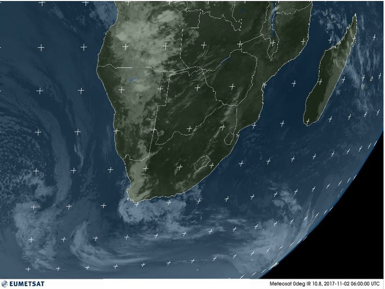
Satellite Image: Infrared photograph of southern Africa at 08:00 central African time on Thursday 02 November 2017, taken when the satellite is directly above the Greenwich meridian. The satellite receptor is designed to capture wavelengths in the 9.8 µm to 11.8 µm range. These are translated to a representation of surface temperature, clouds, wind fields and atmospheric instability.
Source: EUMETSAT
oiswww.eumetsat.org/IPPS/html/MSG/IMAGERY/IR108/COLOR/SOUTHERNAFRICA/
The early Thursday morning Eumetsat Infrared image of southern Africa provides a beautiful summary of what transpired earlier in the week, and what materialised on Thursday and Friday.
At the beginning of the week there was still weak high pressure control in the southern half of the Mozambican Channel. This spilled backed into Mozambique and South Africa and remained there during the week. Within the weak high remnant, air circulation was from south to north in the channel and zonal over the continent, i.e. from east to west. The clear dark blue in the channel and the dark green over western Madagascar and the south-eastern quadrant of the sub-continent, show the high pressure control.
At the same time, the South Atlantic high pressure cell was far out in the ocean, some 4000 km west of Cape Town. This well-defined separation between the high south of Madagascar and the South Atlantic high created a huge expanse (more than 5000 km) with limited high pressure control. In other words, the extraordinary large distance between the two highs created room the size of the proverbial barn door. This door was opened very forcefully by the anti-cyclonic low pressure system that developed over southern Angola and Western Zambia the previous weekend, and riding along with the airflow on the rim of the departing high, a very strong north to south airflow was generated over Namibia. This became a moderately strong trough (laterally mobile low pressure system) that gained strength as it developed towards the south. The result was not insignificant showers over the north-central, central and southern parts of Namibia, with much more substantial showers further south in South Africa.
The satellite image is not a visual in the sense that a human eye or normal camera lens sees objects. It only perceives electromagnetic radiation in a very narrow wavelength band. Thus it must be viewed as a proxy for real conditions on the ground. This is done by an extremely sophisticated computer that translates the captured values to imagery, rendering an image which we can see, interpret and understand. What is shown is essentially vapour, which by definition is transparent but which have a direct impact on the ambient temperature of the atmosphere. It is only later in the day that this vapour turns into clouds, which are then visible on other satellite shots as so-called visuals.
So, the first condition for penetration of moisture from the north, was the “barn door”, the large opening between the two highs. The second factor that aided in no small way the intrusion of moisture, was the so-called cut-off low that developed ahead of the South Atlantic high. As the high approached the continent, the cut-off low grew in intensity and by Thursday it was a visible vortex about 1500 km west of Cape Town. It can be seen in the satellite picture (bottom left corner) as a cloudy spiral with proper cyclonic circulation.
On its leading edge, this vortex drew in massive volumes of air from the north, in the process greatly amplifying the mid-level trough over Namibia taking the moisture as far as the southern Ocean south of Cape Agulhas.
Since the core of the South Atlantic high remained out to sea, the north to south airflow stayed over Namibia for the better part of four days, leading to considerable cloud formation over the central plateau and even over the northern coastal plain (Kunene) on Wednesday.
Widespread light to medium showers resulted over a large area from the Kunene River in the north, across the western half and central high ground of Namibia, up to and beyond the Orange River.
What’s Coming
The South Atlantic high moves closer to the continent during the weekend but with limited impact due to the cut-off low ahead of its leading (eastern) rim. The low shifts into the southern ocean taking much of the high’s strength away to the south-east.
Low pressure conditions are present over the entire Namibia with a pronounced low pressure system over the southern Namib between Sandwich Bay and Lüderitz. Strong south-westerly winds will blow in this area from late Sunday afternoon into Monday.
Low pressure conditions continue over Namibia and Botswana on Monday, with a north to south airflow over the western half, very similar to this week.
The high remains offshore as it slips around Cape Agulhas leaving much space for a more defined low pressure system to develop over the entire subcontinent. The so-called heat-low starts forming again on Tuesday indicating blisteringly hot days for Otjozondjupa along the Botswana border, Kavango West, Bwabwata and the Caprivi section of Zambezi.
Rainfall prospects are not very positive except for a small area in central Namibia covering Khomas and Omaheke on Monday and Tuesday.


