


Weather overview and short-term outlook to Wednesday 09 September 2020
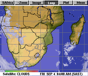
Visual: Animated map of cloud formation early Friday morning 04 September.
Source: Space Science and Engineering Centre, University of Wisconsin-Madison, www.ssec.wisc.edu/ – Note that this link leads to a near-current animated image based on live satellite imagery. The actual visual is delayed by approximately two hours.
Recent Developments
The importance of the anti-cyclonic circulation over the Southern African sub-continent was amply demonstrated when a well-marked convergence zone developed just east of the mid-level trough that started forming on Tuesday. This system brought rain on Thursday, Thursday night and Friday to a wide band stretching from the Botswana border just north of Aminuis, through the Gobabis district, and further to the north-west through Otjozondjupa and Etosha into the northern and north-western areas.
The visual shows cloud development during the coolest part of night, which is also the time when relative humidity at the surface or close to the surface is at its highest. During Friday morning, the same imagery showed much less cloud but with the evidence obtained earlier in the morning from 04:00 to 06:00, it is clear that much humidity entered Namibian air space from Angola. The available readings show humidity between 40% and 60% which is sufficient for low-intensity, intermittent showers.
The convergence zone closely followed the perimeter of the mid-level trough that stretched from Angola through Namibia and into Botswana and South Africa. This is a signature summer feature, so one can make out a case that the kleiner Regen has started early but it is far to early to state that with certainty.
This week also showed the importance of convection. If the moisture that is advected by the trough from north to south, stays at a certain level, it causes haziness but it does not condensate into water. This air column needs to be lifted and that lift is provided by the outer rim of the South Atlantic High pressure cell where it enters Namibia from the south-west at surface level. Where these two opposing systems meet, the colder, denser air from the south undercuts the warmer, moister air from the north, lifting the latter and enhancing convection. This is what produced the rain.
As Namibians, we are neurotic about rain therefore it is only normal that everybody would love to see an early start to the season, but this is a dangerous notion.
There are however, four broader phenomena already in place, which indicate that the odds for an above normal rain season, are in our favour.
1.) Sunspot activity has increased perceptibly during the first half of 2020. Officially, the 25th sun cycle started around the end of November last year but our star is a behemoth that works on very long cycles. So, do not expect too much in the short-term.
2.)The 30-day Moving Southern Oscillation Index maintained by the Australian Bureau of Meteorology is positive again after being negative for most of 2019. The current reading is 11.3, comfortably above 7.5 which is statistically viewed as the La Nina threshold. However, these elevated positive values must endure for at least six months before a La Nina becomes official.
3.) The position of the Inter-Tropical Convergence Zone over central Africa has shifted somewhat southward during the first part of August. The northern boundary has retracted several hundred kilometres across the Sahel but the southern boundary has not moved the same amount. It is still stuck on the Angola DRC border latitude. But if it starts pulling back in the north, it is only a matter of time before the ITCZ as a whole starts migrating south. Again, take heed, it is not before Christmas that we want to see the southern boundary on the Namibia Angola border.
4.) The Pacific Ocean is still ENSO neutral but is has cooled significantly. The US Climate Prediction Centre in the National Oceanic and Atmospheric Administration (NOAA), currently gives it a 60% chance to develop into a proper La Nina during our summer, and a 55% chance that it will continue into autumn.
On the Radar
The mid-level trough through central Namibia stays in situ for the duration of the weekend. It continues to advect moisture from Angola but the air column is relatively stable indicating suppressed convection. The convergence zone shift slightly to the west meaning there is an outside chance of light rain in the areas adjacent to but east of the escarpment.
The next South Atlantic high is fast approaching driving a frontal system. Ahead of this system, a second convergence zone will cross Namibian airspace during Friday night. In effect there will then be two convergence zones, the central one and another, weaker one over the southern Namib. This bring the possibility of light, late winter rain to the Sperrgebiet National Park and up to the Fish River Valley.
Both systems dissipate by late Sunday so on Monday, and for the rest of next week, it should be back to clear skies and lots of sunshine.
On Monday, Tuesday and Wednesday, unstable air penetrates the areas north, north-west and north-east of Etosha. This brings intermittent cloud to the northern areas and the central high ground but rainfall expectations are dim.


