Understanding Weather – not predicting – 01 February 2013
What happened?
No rain of any significance so far and the outlook for much of the new calendar year is only bleak!
But we have had rain, early and quite evenly distributed for quite sometime, so? The value of rain in the ground has its limits: these have been tested to the full during these past weeks.
For some time, even looming before the New Year, the synoptic patterns have shown an unusual pattern in the upper air with the ability to thwart further influence and limit whatever moisture flowed in closer to the surface.
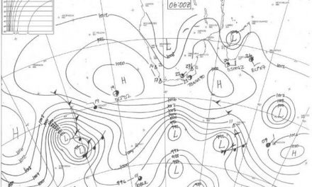
Across our skies and above the South Atlantic, from about 16000 feet altitude thence high in the upper layers a persistent high pressure core has, if anything, become more prominent during the past two months. This means a dry influence dominating whatever weather can develop lower down.
This upper-air high pressure cell is coupled with a low pressure core close to Antarctica around which the regular vortex sequence flowed, yet the core persists. Being the lowest core in the polar area, situated due south of the Cape, it appears these two cores create a restricted space through which surface level anticyclines must squeeze.
Elsewhere in the hemisphere, high pressure patterns are less intense and more mobile i.e. more “normal”.
All this is, for us, reminiscent of either an ENSO influence or a typical winter pattern.
The cyclonic core east of Madagascar seems to have little influence on the present pattern.
Can one explain this unusual synoptic arrangement?
Not really, unless we see this as a clash between the previous “normal” and the global warming influence of the expanding Tropical ranges.
The cause why this develops and persists now as opposed to wintertime is similarly obscure.
What happened was a dry week away from our far northern parts, coupled with dry heat on the western side of the heat low above western Botswana.
The visible development (daily) but with limited vertical structure typified the dry air control these past few days.
What’s coming?
Despite the upper air persistence, the low level anticyclonic core succeeded in tracking closer to 40oS, establishing itself to the south-east of the continent and swirling a broad (but shallow) moist flow inland for the past few days.
The position of the Inter-Tropical Convergence Zone is unclear on our northern border, but the outlooks offer an improving chance for advancing both moist lower level air and some weakening of the upper air grip. A return of thundery activity by weekend into our northern areas is expected.
Southward spread is given a chance, but until a trough (upper air in particular) forms to our west over the Atlantic Ocean, effective rain of 10mm or more with improved intensity remains unlikely.