


Overview for the week and 5-day outlook to Wednesday 08 August 2018
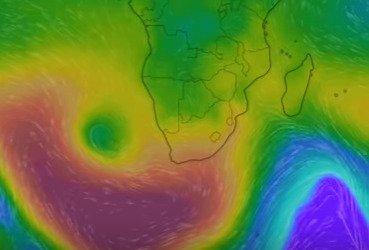
Visual: Clip from a colour-enhanced graphic showing surface highs and lows for the southern hemisphere on Thursday 02 August.
Source: https://earth.nullschool.net based on data from the US Weather Service.
What Happened
The main feature for this week was the presence of a vortex just behind the frontal system that has been slowly approaching the continent from the Atlantic Ocean. The front, in turn, was propelled by the South Atlantic high pressure cell but due to the system’s complexity, it did not develop in a conventional sequence.
Essentially, the vortex reduced the power of the approaching South Atlantic high, opening up some space over the sub-continent for a low pressure system to reach down from Zambia to South Africa, and eventually, by Friday linking up with the offshore area of low pressure.
The visual shows what one can call an animated synoptic “map” where the stepped isobars are instead represented by fading hues. The dark red kidney-shaped area in the lower left, is the South Atlantic high pressure cell. It wraps about two thirds around the vortex which is the dark green spot inside the yellow and red, to the left of the continent. The purple protrusion in the bottom right is the trailing rim of the preceding frontal system which passed the Cape a week ago. Where yellow changes to green is more or less the 1016 mB isobar.
The week’s synoptic progression was indeed very complex with many variables having an influence of the larger, systemic weather developments. This makes any longer outlook beyond a 24-hour horizon, very unreliable. Earlier in the week, the vortex was expected to move close inshore, which did not exactly happen. The vortex remained offshore and once it linked up with the continental low pressure area on Friday, it basically lost its impact.
The presence of the vortex, however, brought some heavy fog, not only to Swakopmund and surrounds but also to extensive tracts of coastline along the southern Namib all the way to Lüderitz, with a steady west to north-westerly wind. Offshore pressures were generally higher than inland, resulting in consistent westerly to south-westerly winds over the interior.
The circulation in the vortex is clockwise, thus it conveyed colder air on its northern rim but the horizontal movement inside a vortex is upward with the result that the cold, dense air from the high is picked up and spread over the Namibian interior but with a lesser impact on the surface than in the middle and alto levels. Still, it did produce windy conditions across most of the interior above the escarpment and the first vestiges of continental haze could be seen on Wednesday.
The visual further shows that the South Atlantic high migrated across South Africa during the week, eventually spreading up the Mozambican Channel, bringing down temperatures in Mozambique, Zimbabwe and southern Tanzania, along with some precipitation. For the rest of the sub-continent, the high was dispelled (on the surface) by the low pressure system that moved from Zambia southward into Botswana.
What’s Coming
With the vortex effectively out of the way, the South Atlantic high moves closer to the continent making landfall on Saturday and spreading to the Karas region during Sunday but surface temperatures are not expected to go below 8°C. The weekend will see a cooler south, a windy, warm central plateau, and hot conditions in the north-eastern quadrant.
This will continue next week with a notable pressure differential between the Orange River valley and the Okavango River, leading to windy and dusty conditions over the interior.
As the high migrates to the east, typical ridging moves in from the Northern Cape. The Karasburg district will be significantly colder during Monday night and Tuesday than the rest of the country.
By Wednesday it will be back to a typical mid-winter synoptic pattern with a strong high (1028 mB) over South Africa. The result is the typical Namibian mid-winter weather: – cold nights and warm to hot days. Cold in the south, warm over the central parts except the late afternoon when it can become hot, and hot over the areas north and east of Etosha.


