


Overview for the week and 5-day outlook to Tuesday 03 April 2018

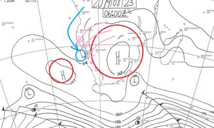
Visual: Extract from the full-disk infrared image from the Eumetsat satellite over the South Atlantic and southern Africa, disseminated by the US National Oceanic and Atmospheric Administration. Image compiled on Wednesday 28 March at 06:00.
Source: http://www.goes.noaa.gov/f_meteo.html
What Happened
This week’s widespread rain over most of Namibia demonstrates just how critical the position of the South Atlantic high pressure cell is to local weather. For the first time in many months, the high’s core lay almost equidistant to Africa and South America, implying that it was more than 3500 km away from Africa. Usually, and for the past five months, it lay about 1000 km offshore from Cape Town.
Early in the week, the South Atlantic high had a complex make-up comprising a weak core over South Africa, a secondary core about 500 km offshore from Oranjemund, and the main core in the middle of the ocean.
During Monday night and Tuesday, the continental core departed while the secondary core shifted south, only impacting the Western Cape. But it was the large distance between the mainland and the main core, several thousand kilometres out to sea, that created the unique conditions for tropical air to reach across the entire Namibia up to the Orange River.
This deep intrusion of moisture would not have been possible without a second driver and this came in the form of a very strong trough that developed from central Africa across Angola into Namibia and beyond into South Africa. The effect can be seen clearly on Wednesday’s satellite image.
Note that the moisture covered the entire central Africa, an area roughly 4000 x 4000 km, coming from as far north as Gabon, amplifying moisture over both the DRC and Angola, then advected by the trough across Namibia. The results were astonishing.
While the rainy weather on Tuesday and Wednesday were rather subdued producing between 20 mm and 30 mm over the two days depending on locality, the absence of thunder showers meant that it rained soft and long. This may not be good for reservoir replenishment but it is very positive for soil moisture, especially later in the year in September and October when grazing stress is at its highest. Expect the grass to sprout soon after the winter this year.
The trough continued to cover most of Namibia except the coastal plain on Thursday but by Good Friday was expected to start clearing from the west. Since the South Atlantic high is still far offshore at the start of the Easter weekend, it is only the southern half of Namibia that will be affected by its approach.
What’s Coming
With the South Atlantic high still two days away, only its outer rim at 1016 mB has some effect on the surface in the two southern regions.
During Friday, Saturday and Sunday, there is much cloud penetration in the south, but convection is suppressed by high pressure conditions in the upper air. Karas and Hardap will have another hot weekend but there is the possibility of isolated showers since the trough has not completely faded.
From around Rehoboth further north conditions are still conducive for scattered showers but it is only from Otjiwarongo further north that rainfall prospects for the weekend remain good.
From around Sunday, there is an expectation for a low pressure system to develop over south-eastern Angola (or just offshore, similar to two weeks ago) which will lead to another mid-level trough from Monday onwards.
Given the relative position of the South Atlantic high, the new trough is also expected to run from the Kunene to the Orange but it is unlikely to develop into the southern Namib. The bias, however, remains in the west, cutting across the western half of Namibia to the Orange River.


