Weather 02 October 2015
![]() What Happened
What Happened
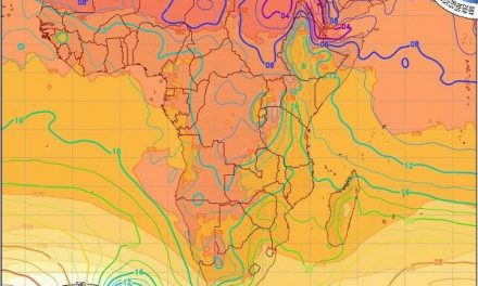
At the beginning of the week, upper level streamlines for the first time this season, departed from their conventional zonal flow from west to east, to a pronounced north-west south-east orientation. This was a response to the well-defined trough that developed at around 18,000 feet (500 mB) running from southern Angola across eastern Namibia and western Botswana into the South African interior.
On the surface level, the week started with a conventional synoptic configuration. The South Atlantic high pressure cell sat about 1000 km offshore from Lüderitz, while its balancing counterpart, the southern Indian high stubbornly remained stuck about 2000 km south-east of Madagscar. The balance between these two massive engines is very delicate and only a few millibars up or down, further west or further east, have a major impact on local weather.
As the South Atlantic high approached, it lead to strong westerly winds on the southern coastline, backing to southerly, and eventually by Thursday, to south-easterly. A massive incursion of cold air occurred reaching the Karas region by Tuesday, and the interior further north, by Wednesday evening.
By Thursday the South Atlantic high has wrapped itself around the southern Cape and it stretched over an almost unbelievable 5000 km from far west over the Atlantic Ocean to the southern limits of the Mozambican Channel. Far south of this high pressure barrier, a massive vortex developed in the proximity of the antarctic circle but the high shielded the continent from its effects.
This late cold intrusion is the effect of the South Atlantic high being blocked by the fairly static southern Indian high. But since the South Atlantic high is such a mighty animal, it must go somewhere and that is north. Hence, like we have had several times during the winter, the cold intrusion is severe. If this week’s intrusion happened in July, we would have had black frost again. Coupled with an intricate series of interlinking cold fronts stretching from the antarctic circle to Cape Agulhas, it set the conditions for advection of cold air from very far south. At this transitionary phase from late winter to early summer, Namibian weather is strongly divided into a southern half and a northern half. The southern half is subject to the vagaries of the South Atlantic high while the northern half gets the impact from the anti-cyclonic surface circulation that covers most of the sub-continent north of South Africa. Inevitably these two systems must meet and it is at this interface where the so-called convergence line forms. Often that line runs smack through the middle of Namibia with a pronounced north-west to south-east slant.
During this week, the convergence line was again prominent. Yet over the southern half, conditions were ruled by high pressure in a relatively thin atmosphere. This is measured as the vertical distance between the 1000 mB and 500 mB isobars. Over the northern half, however, surface conditions are determined by the airflow from Angola and Zambia, in a much thicker atmosphere. The result is the very hot conditions in the north, and the relatively cold conditions in the south.
What’s Coming
As the weekend starts, the massive vortex that originated close to the antarctic circle earlier in the week, has shifted to a position just a few hundred kilometres south-west of Cape Town. The presence of this strong low pressure system weakens the South Atlantic high considerably and prevents its approach to the continent. This creates the space for the southern Indian high to exert more influence over eastern Africa, leading to an enhanced airflow from north to south over the Namibian interior.
By Sunday, only the Karas region feels a limited effect of the new South Atlantic high but the wind will be from the south-east, not the west as one would expect. All areas north of the Karas Region will experience a pleasant but hot weekend.
By Monday, a new trough develops at about 18,000 feet running from Aiona in Angola across the interior to Mata Mata. This will bring in considerable cloudiness but the cloud base will remain elevated. By Tuesday conditions are favourable for rain over the Kunene Region, which may develop towards the south-east covering Otjozondjupa up to the Botswana border. How far south this system will develop remains to be seen.