


Weather overview and short-term outlook to Wednesday 11 March 2020
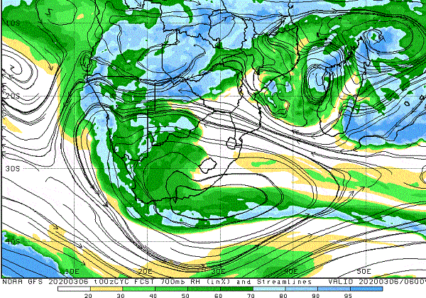
Visual: Relative humidity at 700mB early Friday morning 06 March.
Source: Climate Prediction Centre in the National Oceanic and Atmospheric Administration of the US Government
www.cpc.ncep.noaa.gov/products/international/cpci/data/00/gfs_700mb_rh_safrica.html
Recent Developments
This week saw the slow migration of a rather prominent South Atlantic high pressure cell around Cape Agulhas. The South African Weather Service’s daily synoptic maps showed that the cell’s movement was indeed slow and that it grew in strength as it shifted from west to east.
At the beginning of the week, the core of the South Atlantic high pressure cell sat west of Cape Town about 1000 km offshore with little impact on the continent. As the high migrated to the continent, it started its customary deflection to the south, but it also became much stronger. By Wednesday its core was located due south of the continent, relatively close to land, and reading 1024 mB.
In this position, the high’s leading rim drives a strong south to north airflow which recurved back over the continent, causing high pressure ridging in northern South Africa, Zimbabwe and Botswana. This lead to the unseasonally cold nights in Namibia with the airflow from the east across Botswana, almost like a winter pattern.
By Friday the core has shifted south of the Mozambican channel while the ridging over the mainland intensified, causing higher surface pressure as far west as the Botswana interior.
This week’s visual shows relative humidity at the 700 mB surface. This is roughly 8000 feet above sea level so about 1000 feet above the tops of the highest mountains on Windhoek’s southern perimeter.
When general atmospheric conditions are cooler, as induced by the high pressure control from the east, relative humidity measures higher compared to when it is warmer. Therefore the relative humidity visual must be viewed in the context of the cooler nights. Were nighttime temperatures higher, relative humidity would have been lower and the visual would have looked different.
What is important to notice is that the highest humidity correlates well with the surface trough that developed along the Namibian coastline. This indicates that the trough was a conveyor of moisture from Angola into Namibian airspace but confined to the coastal plain and adjacent interior below the escarpment.
At the same time, a prominent low pressure disturbance was present at the 500 mB surface above Owamboland and southern Angola. The interplay at this level, about 18,000 feet aloft, replicated conditions of two weeks ago. Put simply, it meant that at the level where cloud formation is determined, there was much unstable air (always a good sign) which tended to move south in a cyclonic circulation, while further to the south-east, over Botswana, there was the standard anti-cyclonic circulation over the sub-continent’s interior.
The result was that moisture continued to be advected into Namibia from western Zambia through Botswana, entering Namibian airspace more or less in the area between Mata Mata and Ariamsvlei. This is a good 600 km further south than the previous occurrence two weeks ago. It means that rainfall prospects for the southern half of Namibia are positive and will remain so for a few days.
On the Radar
For the weekend, conditions remain much as they were for the second half of the week. Moisture levels are adequate, around 40%, but high pressure control prevents sufficient cloud formation and convection. Consequently, rainfall prospects for the entire country are only marginally positive with the exception of Bwabatwa and the Caprivi.
If any showers occur, these will be isolated and of brief duration. The bias will remain over the southern half.
These general conditions continue until Tuesday. In the meantime, the coastal trough has morphed into a mid-level trough running across Namibia from Angola to the Orange River, but its development is weak. Very little in the form of rain is expected from this trough.
By Wednesday conditions will change for the better. The mid-level trough is stronger, advecting much moisture into the Namibian interior while the atmosphere across the Namibia Angola border continues to be very unstable at higher elevations. While it is difficult to say that the results will appear next week already, as conditions are developing now, it certainly sets the stage for another bout of good rains from the middle of March onward.


