


Weather overview and short-term outlook to Wednesday 05 August 2020
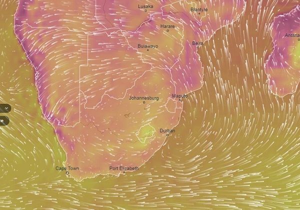
Visual: Computer generated wind and temperature animation for southern Africa
Source: Ventusky.com, https://www.ventusky.com/?p=-26.5;28.7;4&l=temperature-2m&m=icon&w=0DAugjCxA
Recent Developments
This week’s visual is an excellent representation of the so-called ‘bigger picture’ weather. Click on the link above and watch how the animation plays through various selections of wind, temperature, pressure and humidity – all the elements that play a primary role in Namibia’s weather.
The temperature animation was selected specifically as it clearly illustrates the direct link between wind direction and the temperatures on the coastal plain.
Early in the week the South Atlantic high pressure cell was ready to make landfall with its outer rim (1016mB) just offshore the continent’s western coastline. The high shifted relatively fast to the east and by Tuesday the core (1024mB) made landfall between Port Nolloth and Saldanha Bay. It stayed south of the Orange River but a day later, cooler weather penetrated the Karas Region, first from the south-east and then from the east.
As the high’s core settled over the highveld plateau in South Africa, it followed its customary pattern of feeding colder air into the Botswana interior and from their into Namibia. By Friday morning, early morning temperatures over the central interior were also somewhat cooler, although not really cold.
In general, the week displayed a very regular winter pattern with the only exception, the continuing Oosweer at the coast, which, as can be seen in the visual, became very strong and by Friday covered the entire length of the coastline from the Kunene to the Orange leading to several places recording daytime temperatures around 35°C.
For the rest of the country, conditions were fairly normal although the central northern regions were surprisingly also warm to hot with temperatures just touching 30°C in many places around Etosha.
On the Radar
Nothing much out of the ordinary is expected over the weekend with the same conditions as during the week continuing for at least another two days, including the Oosweer at the coast. This should however subside by Sunday evening as the high’s core departs the continent.
Monday, Tuesday and Wednesday are expected to be normal, mild winter days (and nights) but by Wednesday night, the next installment of the South Atlantic high is upon us.
Temperatures in the Karas and Hardap region should drop a lot during Wednesday night, with the cold intrusion reaching the central interior by Thursday.
Although technically it falls outside the outlook window, next week Thursday should be quite cold as far north as Grootfontein and this cold intrusion may stay around until Friday.
A cold spell in early August is not an unusual occurrence. It happens almost every year but next week’s cold intrusion may be more severe than expected. It is possible that frost may occur in the eastern halves of both the Karas and the Hardap regions, and even in the zone between Buitepos and Witvlei, perhaps even in Windhoek.


