Understanding Weather Not Predicting – 13 April 2012
What happened?
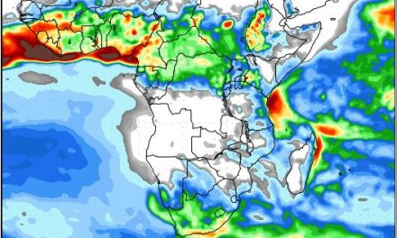
The high interior plateau of southern Africa has a significant impact on the region’s weather. Frequently this geographical factor exerts its influence. This last week provided one more example.
For while, our air space has been non-committal: generally slack wind-flow, not adding much to the existing pattern, but also changing it much.
For the past week, quite an obvious layer of middle air moisture, turbulent in its slender depth too, has persisted..During the period, a gentle increase in potential could be observed. This is April, the ability for dual-weather patterns to exist, more-or-less side by side, is part of the expected scene. When the changed climate patterns are added to this, the whole scenario develops more potently.
The surface level, including the 1000 and 925hPa charts indicate anticyclonic cores hugging the 40oS latitude, at least frequently, and increasing the core pressures when absorbing weaker cores melding from lower (previously the more normal) latitudes. This does create a zone where these stronger cores cut off an area of slacker winds and declining pressures. These are also frequently more marked in the middle layers, again providing a zone for “weather” to develop.
At this time of year the weather focus lies more southerly across Namibia: this remains constant and, by Monday, some development was identifiable, extending into Tuesday.
With an astonishingly steep trough (particularly upper air) crossing the Cape, a brief respite occurred , quickly returning to the more favourable pattern with better shower prospects occurring. So setting the scene for an extension into the new week.
What’s coming?
This overall synoptic pattern holds sway across the week end, with a cut-off development appearing over the ocean far to the west of the Orange river mouth, but inducing advection from, at least, the 25oS area, with rain expected:across the southern parts.
At this time of year, our northern parts have a drier prospect. but the upper anticyclonic control is less apparent. Its core is now further to the east creating some latent potential! The next steep upper trough appears far away to the south in the new week, but the range of its north-westerly, upper air input again holds promise. Few outlooks are hopeful, but the “local” potential is often overlooked, so an open mind persists across these few days.
After the weekend, the next pattern has a similar mix of distant southerly activity and an otherwise quiescent overhead airspace in which almost any condition can evolve. The possibility of an \Okavango shower is not ruled out, but a more extensive showery regime is expected to appear across our southern parts at least with support from an easterly inflow. Falls should be limited, but the activity off-shore should no be discounted.