


Weekly weather overview and short-term outlook to Wednesday 29 January 2020
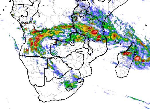
Visual: Part of an animated computer compilation of precipitation over central and southern Africa as at 17:00 on Thursday 23 January.
Source: Climate Prediction Centre in the National Oceanic and Atmospheric Agency of the US Government. https://www.cpc.ncep.noaa.gov/products/international/africa/irloop_af.html
Recent Developments
This week saw plenty of instability in the atmosphere but the active regions were confined to areas outside Namibia’s borders. It was only in the north-eastern quadrant in the Kavango and the western part of Bwabwata that some activity was observed.
Atmospheric moisture is present and entered Namibian airspace throughout the week. This could readily be seen in the visible vapour that penetrated the northern, central and eastern regions. Although moisture was not particularly high, it was sufficient for the same system that did not produce much over Namibia, to develop to full strength with much productive rainfall over central Botswana.
This week’s visual is only one slide from a fairly large file that shows rainfall development from Tuesday to Thursday night. The whole file can be viewed by following the link above and clicking on the ‘step’ button to see the rainfall progression in slow motion.
What can be seen in the visual is the well-defined arch of activity from northern Madagascar into Tanzania and from there across the southern DRC into the Angolan interior. It is also obvious that the bulk of the sub-continent’s rain was dumped in Angola while Namibia, South Africa, Mozambique, Zimbabwe and most of Zambia received scant or zero rain.
Also visible is the impact of the South Atlantic high pressure cell on two thirds of Namibia and most of the western part of South Africa. Furthermore, there is a large high pressure cell in the Mozambican Channel between the continent and Madagascar. This would ordinarily be the continental high which is a transitory phase between the South Atlantic high and the southern Indian high.
In the western parts of the sub-continent, Namibia included, high pressure control was strongest on the surface as witnessed by the two relatively cool early mornings on Monday and Tuesday. On the eastern side, however, the high’s control reached very high altitudes showing up on 500 mB as well as 200 mB maps.
Another visible feature is the signature mid-level trough from southern Angola through the Kavango and into central Botswana. This trough often advects moisture to the Namibian interior but when the South Atlantic high is as strong as this week, the trough is pushed further to the east leaving Namibia’s western half hot and dry.
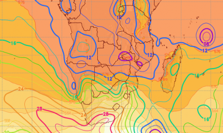
On the Radar
The mid-level trough at about 18,000 feet aloft stays in situ for the duration of the weekend. This translates into a slight chance of rain north and east of Grootfontein but the expectation is for light falls only (1 to 5 mm).
By Monday the trough has moved further to the east, more or less crossing Bwabwata with a remnant lingering over the Kavango and the eastern parts of Owambo.
For the rest of the outlook period, it is only the areas north of Etosha along the Angolan border that have any reasonable chance of rain.
The southern boundary of the Inter-tropical Convergence Zone sits right on the Namibia Angola border but the mechanism that must run the moisture from there into Namibian airspace just does not seem to be able to become active.


