


Overview for the week and 5-day outlook to Wednesday 14 November 2018
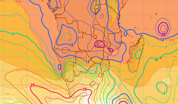
First Visual: Sea Level Pressure for Tuesday 06 November
Source:GrADS/COLA, George Mason University, www.wxmaps.org/fcst.php
Second Visual: Southern Africa Synoptic Map on Wednesday 07 November
Source: South African Weather Service, www.weathersa.co.za/observations/synoptic-charts
What Happened
The two visuals from different sources show the synoptic progressions over two days and how it impacted Namibian weather. It is also a visual display of a larger synoptic picture that still portrays a distinctly winter stance.
This week, for the first time this season, the technical elements are in place to refer to local conditions as a heat wave. This may appear to be anomalous but that is the reason why two visuals were chosen. Specifically to show that earlier in the week local (Namibian) conditions were subject to the control of the high pressure cell on the surface, and that later in the week, as this cell has migrated to the east, the high pressure control came in the stratosphere from its surface source in the south-east.
While Namibia is now well into daytime summer conditions having passed 13 hours of sunshine per day last week, the impact and reach of the South Atlantic high pressure cell must never be underestimated or disregarded. This week is an illustration of this reality check.
The beginning of the week showed a typical synoptic pattern with the South Atlantic high offshore the west coast and the southern Indian high about 1500 kilometres east-south-east of Madagascar.
Over Namibia, the reigning airflow was split between north and south. The southern half had a steady south-westerly to southerly flow while the north, similar to last week, had a steady north-easterly flow with a curve-back over the Kunene region. This led to a fresh north wind along the central Namib coastline which endured for roughly three days.
The South Atlantic high made landfall during Tuesday with a slightly stronger core reading of 1028 mB. 1024 mB is the more typical winter reading so the higher pressure indicates that the cold cell that spread over South Africa was indeed unseasonally strong. (See first visual)
In Namibia the first impact was felt on Tuesday morning, the more severe the further south one looks. This cold intrusion spread to about the Grootfontein latitude but was quickly dispelled during the day by the steady north-easterly flow of warmer air. At that stage there was no discernible ridging. The same pattern repeated on Wednesday and by Thursday the surface impact (cold) of the high was gone.
By Thursday, the first signs of ridging appeared. This is high pressure control in the alto levels (stratosphere) and it is indicated in red on the South African Weather Service synoptic map. When there is high pressure control in the upper air, the airmass tends to sink later in the afternoon when the sun’s energy slowly recedes. This sinking air column, often as high as 50,000 feet, very slowly compresses in the process releasing energy which pushes up the ambient temperature on the surface.

This is what happened late on Thursday and on Friday from just after noon, and will continue on Saturday and Sunday, and into next week.
What’s Coming
The entire Namibia experiences heat wave conditions during the weekend. The extensive ridging, both in geographical area and height, continues for the next four days. It will also cover the entire Botswana and most of South Africa’s North West and Northern Cape provinces.
On the surface, conditions will be somewhat different with the airflow remaining north. This will bring in some moisture and warmer air from Angola, but only between 15,000 and 30,000 feet.
This should produce a shallow layer of cloud around 18,000 feet which has the potential to spread from Ruacana through the interior to the northern parts of the Karasburg district.
But similar to 2016, this will be a flat layer of cloud only, almost like a blanket that serves as a shield against the sun’s direct rays, but can do nothing to prevent the diabatic compression that will continue in the afternoons. This band of clouds may even produce light rain from Omusati through western Etosha into the Outjo district, but the chances are rather slim and any precipitation will be counted in drops.
For the entire country, the days will be blistering, especially the afternoons. It is only after next Wednesday that some shift in the weather pattern is expected. The feature to watch is Cyclone Alcide at the northern tip of Madagascar, marked in blue on the synoptic map.


