


Weekly weather overview and short term outlook to Friday 20 December 2019
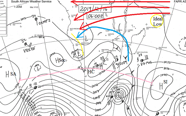
Visual: Synoptic map for southern Africa as on Monday 16 December.
Source: South African Weather Service. www.weathersa.co.za/images/data/specialised/ma_sy.gif
Recent Developments
The past week was marked again by the influence of the South Atlantic high pressure cell. Early last week, two successive cooler nights in the interior gave the telltale sign of the high’s influence, especially after sunset. The result was clear skies over almost the entire country with only a weak intrusion of moisture in the central-north and northern regions.
Over the weekend the high has completed its west to east migration, departing the continent with only a week remnant over the KZN and Eastern Cape coastline (indicated on the visual as HC). In its wake followed an area of lower pressure (L) crossing into Namibia from Angola. This is the first part of what will later this week become the standard mid-level trough.
A slightly anomalous feature is the cut-off low over the southern Namib. This is an unstable system, still developing and it has the potential to draw the southern extension of the trough further south and west. How it develops later in the week will be closely monitored.
The visual for this week was chosen because it displays an unusually complex synoptic pattern. Short of drowning oneself in the detail, the important overall impression is that both high and low pressure systems tend to be unstable and in continuous flux.
But the visual also shows some important elements that will have a bearing on how the rain season pans out by Christmas, and then a bit deeper into future, by New Year.
The first major element is the distance between the southern Indian high and the South Atlantic high’s main core. Indicated as HSI and HSA, this distance is remarkable, much farther than usual. For this comparison, the two secondary highs (H and Hsec) can be ignored since they will both decay quickly over the next 48 hours. This is also corroborated by the continental high’s core’s relative instability as shown by the two 10 knot readings inside HC.
The distance covered by the pink line is almost 7000 km at 40°S. This is substantial and unusual but it is exactly what we want for the main rain season to have four to six dry days, followed by two to three wet days.
Two more elements we need to watch are the so-called Indian Ocean Transport, shown in the visual by the three red lines, and the anti-cyclonic circulation over the sub-continent, shown by the blue semi-circle.
Although the Indian Ocean Transport has not reached full strength (and will not do so until the middle of January), it is reasonably well-defined and active except for the fragmented atmosphere over western Tanzania. What it lacks at this stage, is a pick-up mechanism in the form of a strong low pressure system just north-east of Madagascar (yellow circle). When the tropical cyclones start, this will occur naturally.
The anti-cyclonic circulation (blue semi-circle) is the localised redistributor of the central African moisture that is advected by the Indian Ocean Transport. Its pivot shifts every day. When it sits over the Limpopo Sashi confluence and the South Atlantic high is sufficiently offshore (more than 1000 km), then rain prospects in Namibia are positive.
On the Radar
This Monday and Tuesday see a brief rain window open over the northern half of the country. It is confirmed by the northerly airflow over the interior and the high relative humidity on the surface (<40%).
Rainfall will be confined to the interior east of the escarpment, receding by Tuesday and Wednesday when favourable conditions will be present only north and east of the convergence line (shown in the visual by the short yellow line).
This should be followed by four dry days, except for Kavango East and Bwabwata.
It is only by the end of the coming weekend that we should see another spectacular 4-day rain window which will probably still be active by Christmas.


