Weather 10 April 2015
![]() What Happened
What Happened
The complex synoptic pattern that developed towards the end of last week continued throughout the weekend bringing some spectacular rain to areas in the north, both west and east, as well as across the entire southern half of Namibia.
The complexity of this weather pattern defies forecast models, in many instances leading to local falls far exceeding the expected values in both intensity and duration.
That pattern continued into this week, developing vertically across three clearly defined strata, each with its own impact on both overall and local cloud formation. The strata loosely conform to the conventional division of the atmosphere, surface, middle and upper. (850mB, 500mB and 300mB).
The week began with the usual surface presence of the South Atlantic high pressure cell. However, only the outer perimeter at 1016mB reached land while the core, relatively weak at 1020mB remained far offshore. This was experienced as colder nights and was felt across the southern half. As this high moved around the continent, it gathered considerable strength, reading 1024mB at its core which was first situated just a few hundred kilometres south of Agulhas. As it migrated further east, it gained more strength and moved northwards up the eastern half of southern Africa and over the Mozambican. Channel. This system brought in colder air over Namibia but from the east, not the south.
Meanwhile, in the middle layers, the low pressure system originating in Angola, has moved down the Namibian coastline. This became visible on satellite imagery by Tuesday, growing in clarity during Wednesday becoming very prominent on Thursday. The result was low pressure over the western half of Namibia, from the Kunene to the Orange, weak high pressure conditions over Botswana, and a very prominent high pressure cell over South Africa. By Thursday, the western part of the east-moving high pressure cell has collapsed with only the strong high pressure presence over South Africa remaining. But this was only on the surface.
In the middle layers, the pressure differential between west and east caused a persistent airflow, first from the east and later in the week from the north-east, rotating over the southern African subcontinent like a gigantic wheel. It advected copious amounts of moisture from the Mozambican channel in a wide curve across Mozambique, Zambia and Angola into Namibian airspace.
In the third stratum, the upper air flowed from north to south, creating what can be described as an upper level trough across Namibia from southern Angola into the Northern Cape Province.
At this level, not much moisture was present but these upper air conditions helped to reinforce the very positive conditions in the middle layers, and the absence of a strong high pressure cell in the south-west. It lead to good, widespread falls penetrating deep into the Hardap and Karas regions on Wednesday and Thursday.
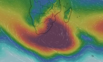
Boosting this conglomerate of interactive stratified atmospheric conditions, is the presence of a very strong tropical depression some 2000 km east of Madagascar. This vortex puts the moisture in the middle layers from where it is advected by the high over South Africa along its northern perimeter across southern Africa.
What’s Coming
Conditions this week are an almost exact repeat of conditions early in March, a month ago. The vortex in the southern Indian Ocean continues to work its magic while the high over South Africa, only slowly migrates to the east, slipping past Madagascar on its southern side. The low pressure over western Namibia remains in situ, effectively splitting the country into a western half and an eastern half.
Rainfall conditions remain positive during Friday, Saturday and Sunday for the western half and for the south. By Monday next week, the next South Atlantic high arrives with a strong influence on surface conditions. This will lead, again to colder nights but only over the southern half up to Windhoek. The northern half will remain warm to hot, and even very hot north of Etosha. By Tuesday, the southern Namib, Karas West and Hardap West, will be considerably colder, possibly even below 10oC with a fresh south-westerly wind that will later veer south. However, the active middle layer system remains intact and rainy conditions may return for most of the country by Wednesday or Thursday next week.