


Seasonal weather overview for Friday 05 August 2022
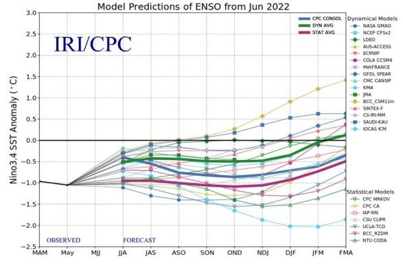
Visual: ENSO forecast plume from August 2022 to April 2023.
Source: Climate Prediction Centre, US National Oceanic and Atmospheric Administration.
Recent Developments
These past ten days saw some local movement in what has otherwise been a rather static, balmy winter. Last week’s frosty conditions over much of Namibia south of Grootfontein, was only the second sub-zero intrusion of any substance since the frost on 16 June.
Today’s synoptic chart (Friday 05 August 2022) shows why we have had such a mild winter up to now. The core of the southern Indian high pressure cell is a relatively normal 1024 mB while the South Atlantic high pressure cell only measures 1020 mB. This does not sound like much but because high pressure cells are such massive monsters, a mere 4 mB difference causes fairly significant weather anomalies.
Since the southern Indian high has regularly been stronger than the South Atlantic high, it produced a phenomenon that we usually only associate with summer and that is the anti-cyclonic circulation over the southern African subcontinent. On the ground it was intermittently visible as a strong northerly airflow, bringing in warmer, moist air from Zambia and Angola. This also produced the irregular, unseasonal cloud formations seen since the middle of June. During the two middle weeks of July it produces significant but isolated rain showers in the eastern half of the Hardap and Kharas regions.
Note that the moisture for these cloud systems came from the north, so it was not a spillover of the Western Cape’s winter weather, it was a proper mid-level trough (like in summer) running from Angola through Namibia into South Africa. In the South African interior where the trough was blocked by the presence of the migrating South Atlantic high south of Cape Agulhas, the precipitation was an order of magnitude more than our local precipitation.
The anti-cyclonic circulation over the subcontinent is the result of the airflow on the outer rim of the departing southern Indian high. The part of the high that sits over land (South Africa, Zimbabwe and Botswana) is a protrusion of the southern Indian high when its core is in the Mozambican Channel or over Madagascar.
When the South Atlantic high is weaker than the southern Indian high, the anti-cyclonic circulation finds room to develop during summer (a weather anomaly) and to expand further westward, i. e. into Namibian airspace. When a mid-level trough is present (another weather anomaly in winter), it acts as a conveyor belt, transporting the clouds over Namibia’s eastern half from north to south. This is what we have seen on several occasions during July.
The visual for the week is a so-called forecast plume based on a range of both dynamical and statical models. One does not need to break one’s head over the technical distinctions, suffice to say that dynamical models use previous forecast values while statistical models use actual conditions. For this reason, the statistical models are a more reliable predictor for Namibia where the weather is notoriously difficult to predict because of its erratic nature.
The important line to follow in the visual is the fat, pink line in the lower half of the plume. That line represents the average of the seven forecast members on the right of the graph.
What is shows is that the current La Nina is expected to be marginally weaker during August and September, and then start growing stronger in October until January 2023. The forecast plume does not show a very strong La Nina, only about 1°C colder than the seasonal average but still strong enough to be classified as a La Nina. In any case, the La Nina of late last year and early this year, also only deviated by 1°C.
Although it is way to early to state with any confidence, tentative indications point to another good to very good rain season for Namibia. CPC models and forecasts are usually fairly robust (perhaps the most reliable in the world) but even they can be wrong. Conditions may change either slower of faster than what they predict, but going by what the plume tells us now, we are in for another above normal rain season. There is also a chance that the very first proper summer rains may occur over the interior still during August, maybe in the three to four days immediately following full moon on 12 August.


