


Fortnightly weather overview and short term outlook to Wednesday 11 December 2019
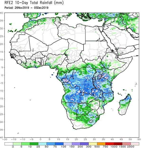
Visual: Accumulated precipitation for the 26 November to 05 December decad.
Source: Climate Prediction Centre in the National Oceanic and Atmospheric Administration of the US Government. www.cpc.ncep.noaa.gov/products/international/africa_rfe/africa_rfe_10day_af_obs.gif
Recent Developments
Since the first seasonal rains started on Monday 25 November, the daily synoptic chart has shifted perceptibly in a more favourable direction.
The most important observations are that the lateral spacing between the southern Indian high pressure cell and the South Atlantic high has increased considerably, i.e. by more than a thousand kilometres, core to core. Further, both highs have remained more or less at a barometric pressure of 1020 mB. This is neither high nor low but at least it indicates that the winter pattern (1024 to 1032 mB) has departed. Finally, the upper level high pressure control over East Africa has subsided although there is still a weak vestige over central and western Tanzania, and a much stronger presence over Zimbabwe and central/southern Mozambique.
What has happened in Namibia is amazing. The previous week’s activity was restricted to an unstable convergence zone running from the central-north through the central interior on to the Botswana border. The cloud base sat around 12,000 feet and there was much convective activity as witnessed by the many thunder storms. All activity was restricted to the mid-level trough from Angola through Namibia into Botswana and South Africa. This is a standard summer feature of our weather.
This week’s cloud cover originated from an entirely different system. Over the past three weeks the southern boundary of the Inter-Tropical Convergence Zone has shifted closer and closer to the Namibia Angola border but it has still remained solidly outside Namibian territory (about 200 km into Angola). It needed a shift in conditions much further south before a perceptible change could happen. That difference came from the distance between the southern Indian and the South Atlantic highs.
At the beginning of this week the South Atlantic high has just migrated across the southern Cape but still with its regular ridging back over the eastern parts of South Africa. However, the next approaching South Atlantic high was nowhere in sight, in fact it was almost 2000 km offshore. This enabled the anti-cyclonic circulation over the sub-continent (another standard summer feature) to advect moisture from the ITCZ in Angola, first into the central-north regions and from there in a wide swathe across Namibia’s interior, deep into the south, and from there into South Africa.
This system comprised tropical air in the lower, middle and upper levels of the atmosphere. It could readily be observed in several places where the cloud base actually touched mountain tops. Three other indicators of its tropical origin was the persistent light rain, the absence of lightning and the generally windless conditions.
This week’s visual provides an overview of all the rain that fell in a ten-day period. It shows the path followed by the vapour system but it also shows that the moment the South Atlantic high comes closer to shore, the system from the north is deflected away from the southern Namib and the areas above the escarpment in the southern regions.
On the Radar
The rain-bearing system remains over the northern, central and south-eastern areas for the weekend but clears from the west as the next South Atlantic high approaches.
There is a reasonable chance for light rain in the same areas that received good rain this week but the totals, if any, will be much less.
A cut-off low is expected to form offshore from Lüderitz during Sunday which may bring windy overcast conditions to the southern Namib. The rain potential, however, will be very little.
As the tropical system moves to the east, the skies start clearing by Monday. On Tuesday it is expected to be dry except for the Caprivi since the tropical system will then be located further to the east, covering Western Zambia, Bwabwata, the Caprivi and northern Botswana.
By Wednesday, the skies should be clear for the entire country and the temperatures back to hot.


