


Weekly weather overview and short-term outlook to Friday 15 November 2019
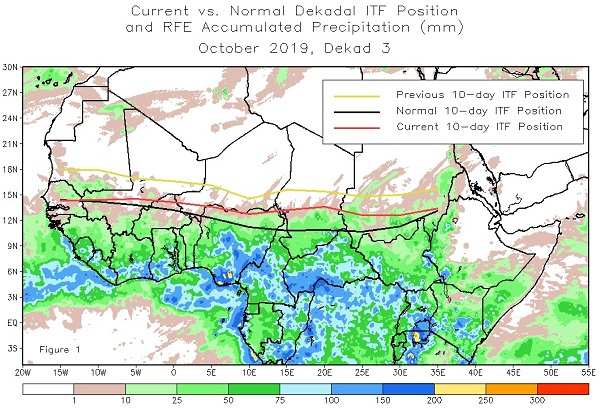
Visual: Northern boundary of the Inter-tropical Convergence Zone across Africa
Source: Climate Prediction Centre of the National Oceanic and Atmospheric Administration in the US, www.cpc.ncep.noaa.gov/products/international/itf/itcz.shtml
Recent Developments
The position of the so-called Inter-tropical Convergence Zone (ITCZ) is the overriding element that determines the duration, quantity and spread of summer rainfall in southern Africa. It is therefore critical to understand what the ITCZ is, when does it move into southern Africa, and what conditions oppose its innate rainbearing characteristics.
This week’s visual shows the estimated position of the northern boundary of the ITCZ across Africa. The yellow line is where the ITCZ was on 10 October while the red line shows it ten days later. The black line is the average position based on data from 2003 to 2013.
The ITCZ is the area north and south of the equator where the easterly or trade winds from the northern and southern hemispheres converge hence its name. Over the ocean it is fairly narrow, in the region of about 500 km from south to north. Over land however, it tends to spread either northward or southward, far from the equator depending on the season.
Since it is by definition a low pressure zone, it wanders north or south as the sun shifts north or south. Thus, in the austral summer, it moves to the south, often by more than one thousand kilometres when it is over land.
Pinpointing the ITCZ is not always that easy but it is relatively safe to say it is mirrored by realised rainfall on the ground. The Mauritius Meteorological Service does the best job in our neck of the woods to keep track of the ITCZ which is almost always present over the Indian Ocean north of the northern tip of Madagascar.
As the summer progresses, the ITCZ wanders southward over southern Africa, typically up to an imaginary line that cuts Angola in half, then runs through Zambia, and exits the continent more or less at the Ruvuma River, the border between Mozambique and Tanzania.
As can be seen from the visual, it shows a measurable mobility for every ten days that it is measured. Also, keep in mind that the American interest lies in the ITCZ’s northern boundary because the North Atlantic is the region where their hurricanes originate.
On the ITCZ’s exact southern boundary, not so much is available, not only because the meteorological data is modest in southern Africa, but also because the terrain offers a far wider area in which to expand. (Finding the northern boundary in Africa is fairly easy since the Sahara desert is such a formidable natural barrier).
Following NOAA’s precipitation maps and forecasts for Africa, is usually the only way to get an idea of where the ITCZ is and how mobile it is. In the absence of more reliable data, the actual and projected precipitation maps serve as a good proxy to determine the position of the ITCZ’s southern boundary.
Since the entire ITCZ is one contiguous system, it follows naturally that if the northern boundary is behind schedule retracting to the south, the southern boundary is probably also behind schedule. Note, this is not a proven fact but an inference but it is the same assumption that NOAA works on to put their precipitation forecasts together.
At this time of the year, the ITCZ’s southern boundary is usually more or less at Lubango in Angola. That this is the case, is supported by the good rains Lubango has had over the past two weeks.
The important consideration for Namibia is that the ITCZ must be at the Namibian Angolan border by around Christmas. This is its normal position. It is then positioned in such a way that any three to four day wet spell translates into the advection of vapour into Namibian airspace, leading to widespread thunder storms.
During the past week, cloud formations in southern Angola continued to improve on a daily basis. This may or may not have been an extension of the ITCZ. (It is too early too tell) But it created conditions that were positive for rainfall in those areas of Namibia within a few hundred kilometres of the Angolan border and over the weekend it extended even further south, albeit very briefly.
The important observation for us is that the ITCZ is almost where it is supposed to be at this point in time, and that if it continues to develop southward, it will be on the Namibian Angolan border when the main rainfall season starts after Christmas. The problem area is still western Tanzania where the ITCZ currently is either absent or fragmented and until those conditions change, we will not get good rain.
On the Radar
By Monday, the South Atlantic high pressure cell sits south-west of the continent with a core reading of 1024 mB, a fairly normal late winter value. The core is about 2000 km away from the continent.
Over the next four days it migrates around the southern tip of the continent but the core remains offshore by several hundred kilometres so the inland impact is absent.
In the meantime, the heat-low over northern Botswana remains in place leading to very hot conditions over Kavango East, Bwabwata and the Caprivi. The areas further south along the Botswana border up to about Aminuis, will also be very hot with very little or no wind.
Note, this is not a heatwave as popularly but erroneously believed. It is heat generated by the number of sunshine hours per day over the large, flat interior plateau of the subcontinent.
Similar to conditions over the weekend, rain is indicated for the northern and north-eastern quadrant including the Caprivi, but only for Monday, Tuesday and Wednesday.
By Thursday, the mid-level trough is situated across eastern Botswana and into the eastern highveld of South Africa leaving very little moisture over Namibia.
Acknowledgement: A big Thank You to Rob Moffett of Ongava Game Reserve who brought the updated work on the ITCZ to our attention.


