04 July 2014
![]() What Happened?
What Happened?
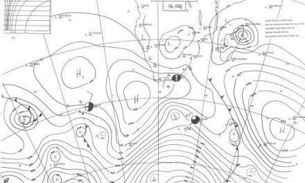
Despite the presence of two very dominant high pressure cells, one over the south Atlantic and another south of Madagascar, the Namibian weather was strongly under the influence of the low pressure area between the two.
The week was generally mild to warm depending on latitude. The airflow was prominently from the north and the north west creating a broad swathe of low pressure flowing from Angola across Namibia to South Africa. On the surface, both at sea level and on the inland plateau, low pressure control brought in warmer air from the north, dispelling the cold approach from the south. In the upper air, and quite anomalous for winter, low pressure control prevented the northern circulation of the high pressure cell over the sub-continent, to reach Namibian skies. In the upper air, i.e. above 35,000 feet, the core of this high pressure cell at one point during the week, was situated over Zambia. This is indeed very far north for any high pressure cell to exert an influence on local weather, but it is the reason for the strong north south airflow, and for the milder conditions.
This air flow from the north brought in some moisture in the middle layers, enough to lead to overcast conditions over the Karas Region earlier in the week. Some precipitation was indicated for the area south of Keetmanshoop and east towards Ariamsvlei. Scattered cloud was also present over the central plateau earlier in the week, leading to more visible cloud formation in the east towards the end of the week.
By the end of the week, a very strong South Atlantic high pressure cell sits relatively close to the continent, but its core is far south. This high exceeds the previous in intensity, measuring some 1040 mB at its core, but an equally dominant low pressure area running ahead of it south of the Cape, siphons away a large part of the immediate impact from the cold front preceding the approaching high.
As long as there is low pressure control both on the surface and in the upper air, the cold fronts will be limited to the southern extremes of the Karas Region.
What’s Coming?
The South Atlantic high pressure cell whose influence was already noticed during Thursday night, makes landfall this Friday. Temperatures in the south drop dramatically during Friday night with a strong airflow from the south. This effect has an impact to the north but only up to about Windhoek. The northern half of the country should remain mild to warm.
The passing cold front brings in much colder weather during Saturday and Sunday, but limited to that part of the country south of Otjiwarongo. Two leading forecasts expect next week to be generally cooler as the high pressure cell moves east and settles over South Africa. By Monday, temperatures in the south should be slightly up, while the wind backs to the east. However, the intensity of this high pressure cell is limited by upper air control of the low pressure area that follows in its wake.
So, next week in general will be cooler, but except for the Karas Region, will not be frosty. The low pressure system that moves past the Cape has the potential to bring in winter rain to the Sperrgebiet, and possibly to the areas as far east as Aussenkehr.
The wind will first be from the south, then backing to the east. Later in the week, it will revert to north. Again, strong winds are expected for the coast but in opposing directions, from the south for the south coast and from the north west for the north coast.