


Weekly weather overview and short-term outlook to Wednesday 31 July 2019
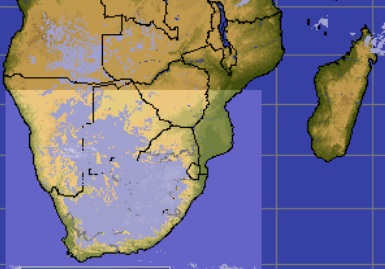
Visual: Cold weather over southern Africa at 07:00 on Friday 26 July.
Source: Space Science and Engineering Center, University of Wisconsin-Madison
http://www.ssec.wisc.edu/data/paw/clouds/eueu_soaf_clds_anim_none.gif
Recent Developments
This week’s visual provides an interesting view of the fairly sharp cold that penetrates the Namibian interior at night, but then rapidly dissipates soon after sunrise.
The image was taken early Friday morning about half an hour before sunrise. At first glance, it may appear that the whitish area covering much of South Africa, Botswana, Namibia, southern Angola and Western Zambia, may be clouds but a closer inspection of the sequence of images shows that it is actually the area where the surface temperature is close to zero.
The satellite telemetry is based on refraction. This is simple physics and has little to do with meteorology. The satellite’s sensors measure wavelength and works on a simple principle: – colder conditions produce shorter wavelengths while warmer conditions send out longer wavelengths. This is all the satellite captures. A computer then translates the raw telemetry, interpreting the differences in wavelengths as changes in temperature and draws a two-dimensional picture which is what one sees when looking at the visual.
The satellite’s observation equipment does not have the ability to distinguish between cloud tops and surface cold, that is why it produces a picture that looks like clouds but in reality, only shows very low temperatures at ground level.
The fleetingness of these cold conditions are confirmed by the next image, taken only an hour later, when all the white has disappeared. (Not shown)
The system that passed through southern Namibia on Tuesday was not a frontal system in the technical sense. It was the northern extension of the cyclonic circulation that approached from the South Atlantic. At that point when it impacted Namibia, the true front was long gone, situated somewhere over the South African interior.
But it did produce light precipitation over the Sperrgebiet. The private weather station at Klein Aus Vista measured 0.8 mm while conditions in Oranjemund were heavily overcast with some spillover to Lüderitz. However, the problem with accurate measurements over the southern Namib is that there is virtually no human presence or settlement outside the four main towns, – Lüderitz, Aus, Rosh Pinah and Oranjemund, all located on the periphery of this very large, desolate tract of land. It is therefore practically impossible to state exactly how much it has rained in the Sperrgebiet, it can only be inferred.
Nevertheless, this environment is very dependent on the few millimetres it receives during winter and the one-day wet conditions brought a welcome respite from the super-arid conditions which have lasted several years.
For the rest of the country, it was a continuation of the normal mid-winter pattern. The nights were cold, (colder than expected) as amply shown in the visual but pervasive high pressure control in the alto levels lead to warm, even hot afternoons depending on latitude.
On the Radar
Local weather over the weekend and into next week is an almost exact repeat of conditions this past week with the only exception that the low-pressure disturbance will be one day earlier next week.
The South Atlantic high, still some 2000 km away, again pushes a low pressure system ahead of it. This system will make landfall in the Western Cape during Monday, extending northward to the Orange River but not expected to reach Lüderitz. It will advect very cold air during Monday night into the Karas region, spreading to the Hardap and Omaheke regions by Tuesday.
By Wednesday, it will all be over and the weather over the interior will resume the same pattern it has followed for the past month.


