Understanding Weather – Not Predicting 09 December 2011
What happened?
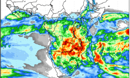
This week was marked by a cut-off low over the Orange River in the south and a broad trough of tropical moisture moving in from Angola in the north.
The persistent cloudiness above northern and central Namibia, again being fed from mid-continent kept both rainy prospects and the southward movement active. Such patterns are mobile and can react very quickly but the current patterns held course and the cloudiness from the south linked up with the more robust cloud from the north.
In the south, the system was being carried away into the Karoo, but with the undercutting of cooler air widespread showers developed across the southeastern parts. 88.5mm was measured at Koes. When one considers that in the drier years, the season’s total can well be less than 88, the intensity of such a weather pattern is understood.
But the favourable air-flow continued. The core circulation remained above the eastern Zambezi catchment thus ensuring a steady, curving and intense flow above Namibia (in particular). Although there has been no well-marked convergence area the latent instability of such an airmass ensures developing thunderstorms recur daily.
Meanwhile, the Atlantic anticyclone persists in mid-ocean feeding the cold side of a vortex pattern, with cold frontal activity, lying across the Southern Ocean from near the Cape down to the Polar vicinity. The cold front ensured another coastal low would form and run down the coast as the cold front approached.
The core of the continental anti-cyclonic system driving the influx of tropical moisture shifted from over Zimbabwe to over southern Angola by the end of this week.
What’s coming?
Interestingly, as the days progress, the persistence of the rain-making pattern is extended. There is no major departure from the unusual (for December) pattern. The South Atlantic anticyclone remains around 35 to 40oS in the Tristan/Gough longtitude. Its activity maintains a complex vortex system well south of the continent, generating 2 troughs in the next few days. The most intense appears after the weekend curving the isobars deep into the upper air. The ability to tap the resident moist air mass lying across Angola, northern Namibia and western Zambia persists.
Forecasts expect thundershowers to continue across northern and northeastern Namibia, extending into the central and eastern parts.
The anti-cyclonic core is expected to migrate eastward again taking the rain-bearing cloudband with it. By Tuesday, conditions over the central plateau will start clearing with most of the rainfall concentrated in Omaheke, Otjosondjupa and Okavango. In the north the system will continue to reach westward up to Kunene.