


The Week’s Weather up to Friday 24 February Five-day outlook to Wednesday 01 March
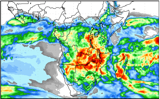
Precipitation forecast from Friday 24 February to Saturday 04 March
Source: wxmaps.org, GrADS/COLA
The Inter-Tropical Convergence Zone is by definition an extensive low pressure band that runs around the globe straddling the equator. This band lies between 10°N and 10°S latitidues, thus just over 2000km wide. It tends to be better defined in the northern hemisphere than in the southern because there is more land in the northern hemisphere at that latitude. However, in the austral summer, it wanders far to the south from its usual containment. Then it appears in Africa, South America and Australasia, sometimes as much as 1000km further south than normal.
Over the ocean, the ITCZ is not easy to detect for the frequent absence of cloud. But its effect can be traced in the trade winds that blow from east to west and in the southern hemisphere, at a slight south-east to north-west orientation. When in summer, the ITCZ wanders away from its central Africa location, these so-called zonal winds from east to west, play a very important role to transport moisture from the Indian Ocean into central Africa. The further south the ITCZ is displaced, the more important its moisture transport role. This is the case for southern Africa, and it is the mechanism that was vividly displayed with the recent wet spell, and during this week.
On the Atlantic side of the continent, the ocean is generally cooler than on the Indian side. This cold water is the surface anchor of the South Atlantic high pressure cell. The outer rim of this high typically enters the continent on the Namibian and southern Angolan coastline. Its tendency is to blow from south to north, but this can vary considerably depending on the location of the high’s core relative to southern Africa. This system opposes the inflow of moiture from the north-east.
A strong ITCZ continues to be present from northern Madagascar across the Mozambican Channel into Mozambique, Zimbabwe, Zambia and southern Angola. By the end of this week, the southern boundary of the ITCZ was located on the Namibia Angola border, at around 18°S latitude. On the eastern side, it was even a bit further south pushing deep down the Mozambican Channel.
On the western side, the outer rim of the South Atlantic high, reading 1016mB made landfall on Tuesday, clearing the clouds over the western half of Namibia and pushing the cloud base up to about 14,000 feet. The result was a relatively dry week despite daily intrusion of cloud in the mid-levels. Less than a week ago when fog was present over large areas of the interior, the cloud base was around 5500 feet above sea level, indicating that it was right on the surface above the escarpment hence the reason for the fog.
Between the approaching South Atlantic high and the southern Indian high, an intermediary high pressure cell formed, just a few hundred kilometres offshore the southern Cape. This in-between high controlled surface conditions over the eastern half of South Africa, but its northern rim also acted as a strong driver to amplify the east to west airflow just north of Madagascar.
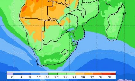
The result is continuing positive rainfall conditions but not for Namibia, southern Botswana and the South African interior.
This week was an interlude between the previous wet spell and the next intrusion from the Indian Ocean, which is expected to reach Namibia next week Tuesday.
What’s Coming
A well-demarcated convergence line is present from Nkurunkuru through the north-eastern corner, through the middle of Botswana across South Africa through the Free State and Kwazulu Natal.
West of this line, cloud penetration continues every day, but rainfall conditions remain negative. East and north of this line, rainfall conditions are positive.
The leading edge of the approaching South Atlantic high slips around Cape Agulhas on Saturday and Sunday. The high’s impact reaches far north up to the Orange River latitude. By Sunday, the eastern half of southern Africa is again under high pressure control.
This creates an opening for a low pressure system to develop along the Namibian coastline, advecting moist air from Angola into Namibia’s western half. With the ITCZ still on the Namibia Angola border, all it needs to sends moisture southward, is a little push, and the growing low pressure system provides this.
The process continues through Monday and by Tuesday a strong mid-level trough runs from Angola through Namibia and into South Africa. This sets the stage for a second wet spell.
From Tuesday onwards rainfall conditions are positive for the whole Namibia excluding the southern Namib and the western half of the Karas Region. The system can however, wander further west than forecast, so there is a reasonalbe expectation of cloudiness over the far South. If it will produce rain remains to be seen.


