


Weekly weather overview and short-term outlook to Wednesday 16 January 2018
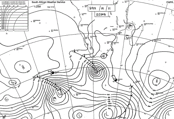
Visual: Midday synoptic map for southern Africa and the southern seas as on Friday 11 January
Source: South African Weather Service, www.weathersa.co.za/observations/synoptic-charts
Recent Developments
Southern Africa’s weather is prone to a large influence of the two major high pressure cells either side of the continent. In the west is the South Atlantic high pressure cell and in the east, the Southern Indian high pressure cell. These two are links in a chain of high pressure cells in the so-called high pressure belt, i.e. the area of high pressure control between the tropics and the Antarctic that circles the southern hemisphere roughly between 20°S and 40°S.
Shortly after Christmas, Namibia’s northern half has been dominated by an influx of tropical air from Angola and Zambia. This could be seen in the low cloud base around 10,000 feet, the dark grey colour of the clouds and the fluffy texture of tropical clouds.
A middle layer of clouds was also visible, leading to some impressive localised cloud formations of the more familiar cumulonimbus (CB) type. These produced widespread thunder showers but they were highly isolated and scattered over a vast territory. Some areas got good rain while others relatively nearby only saw drops.
Windhoek, for example, have several stations reporting a season-to-date total of close to 100 mm with many other areas now only between 50 and 60 mm. The variance between the figures shows the erratic nature of the holiday rainfall.
Further north, rainfall totals are higher, but south of Rehoboth, close to nil except for the Karasburg district along the South African border. These conditions were present until around last week Friday, 04 January.
As of this week, a remarkable change has become visible. Not only were the skies almost completely devoid of clouds, the only regions where some precipitation occurred were Otjozondjupa along the Botswana border, Kavango East, Bwabwata and the Caprivi section of Zambezi. Even here nothing spectacular happened and falls above 20 mm were the exception.
The reason can be seen on this week’s visual. Friday’s synoptic map shows a weather stance that is in essence a winter pattern. This is corroborated by the continued light showers in certain areas of the Western Cape.
The core of the South Atlantic high pressure cell, despite not being very strong, is displaced to the north by a good one thousand kilometres, and the southern Indian high, although somewhat stronger, is also too close to Madagascar. Furthermore, the lateral distance between the two cores is relatively short meaning a rainfall window will occur less frequently than would be the case in a normal year.
In the Regional Consensus Forecast published by the Weather Working Group of SADC in Lusaka in October last year, a so-called “false start” was mentioned as a possibility. Going by the current weather stance, that is certainly a possibility. For as long as the South Atlantic high remains displaced to the north, Namibia will not get good rain.
Further afield, it is noteworthy that the equatorial Pacific Ocean is definitely in the first phase of a weak El Nino which does not bode well for us. Also, the Southern Oscillation Index of the Australian Weather Bureau, which got to an index value of almost +10 late in December, has quickly receded over the past week, now with a value of only +5.6. Again, as long as this index stays under +7, chances for good local rain are very slim.
The impact of the South Atlantic high was felt every night this week. Compared to last week when nighttime temperatures did not go below 20°C, this week was considerably cooler, going down to around 12°C Tuesday and Wednesday night. This is the South Atlantic high at work, showing us just how important its relative strength and locality are.
On the Radar
For the duration of the weekend, the South Atlantic high continues to reign supreme. The skies over most of the country will be clear and cooler nighttime temperatures will be experienced up to Grootfontein.
A large area of lower pressure (during daytime) is situated over the western half of Botswana just touching the Namibian border and covering Kavango East, Bwabwata and Zambezi. This indicates very hot afternoon temperatures.
Due to the large pressure differential between the Atlantic ocean and the Botswana interior, the Namibian interior will be prone to windy conditions. The closer to the escarpment, the more windy it will be.
By Monday, the high pressure cell has migrated to the east opening a small window for an influx of moisture from Angola. The effect will be limited to the areas north of Etosha. Some alto-level cloud will begin to form over the country’s northern half but are not expected to lead to any rain.
Tuesday and Wednesday should see improved conditions for the northern half, but the westward development of the trough is uncertain. It may however develop further west and south than currently expected.


