22 november 2013
 What happened?
Weather’s complexity is based on the variety of ingredients within the air mass at a given time of observation, across a range of the country coupled with the potentials for development which are on offer. Attaching this picture to the time of year expands the view of the prospect accordingly. Our unique climate adds another two aspects: that of locality and variability.
Right now, the stage is well set for the start of the next season.
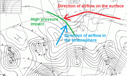
The adjacent Torrid belt has arrived within its assumed latitudes of activity: some 10oN, across the Equator extending to some 15oS, with airflow patterns ready to advect vertical levels into and across southern Africa.
This last week kept a moist inflow in the middle levels from mid-Angola across our northeastern districts and thence across Botswana, very much in keeping with the climatological norm for the time of year. Surface moisture lies to the east of this lower pressure trough. Thunderstorms associated with this band are depositing some very heavy falls: Nkurenkuru’s 44.7 on Wednesday is a good example of what such air can achieve.
The influence of variability can see movement either to the west or the east associated with some variation of the core of the airflow, but the absence of other adverse influences limits the excesses of the variability range.
Does this mean a normal season? At this stage, the prospect is far more positive or rather less negative than a year ago. The spread of the rainy potential, leading on from this current pattern, offers few limitations in either geographic spread or rainfall intensity. Extreme weather anomalies seem unlikely, given current conditions.
Weekly rainfall in mm
Katima:0.4, Rundu 5.5, Nkurenkuru 44.7, Okongo 15.5, Eenhana 0.6, Oshikango 5.2, Ondangwa 0.5, Outapi 10.5 and Tsumeb 6.6. Detail obtained from Namibia Meteorological Service (www.meteona.com)
What’s coming?
Anticyclonic cores prevail between 35 and 40oS limiting cold front activity to similar latitudes while also assisting lower level moist advection toward the mid-continental heat-inspired surface trough, i.e. low pressure area. Above this, the moist input continues. As the dominant airflow from the southern ocean moves over the eastern half of southern Africa, it pushes the core of this low pressure area towards the west. When it settles more or less above northern Botswana, local rainfall prospects are good. This is exactly what is expected for the weekend and for most of next week.
At the same time, with the Equatorial Pacific remaining on the activity sidelines the further outlook offers scant departure from this passive state. That more local, positive influences can emerge within the generally favourable pattern, with daytime heat not to be ignored. Heat causes convection and convection leads to precipitation. Both elements are now in place.