


Overview for the weekend and 5-day outlook to Friday 06 July 2018
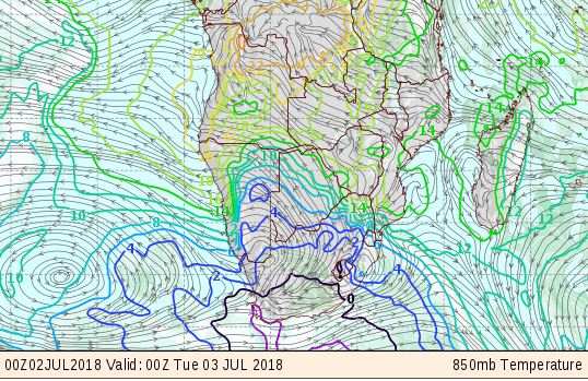
Visual: Surface outlook for temperature, humidity and wind (850mB) for Monday 02 July
Source: GrADS/COLA, George Mason University, Fairfax, VA.
What Happened
A cold front pushed along by the leading rim of the approaching South Atlantic high pressure cell caused temperatures to plummet on Sunday evening. This rapid transition to serious cold was preceded by a milder week with the Namibian interior protected to some degree by the presence of a relatively strong continental high.
What we saw from last week going into the weekend was a very typical occurrence for the local winter. The continental high, while cold and dense in itself, only managed to reach a barometric pressure of 1020 mB. This is in the lower zone of mid-winter pressures. The general reading is usually 1024 mB. Anything that goes above this value indicates a South Atlantic high stronger than normal.
What approached the mainland at the end of last week was a monster 1032 mB South Atlantic high that stretched almost 4000 km out to sea. It was indeed the strongest so far this winter and of such vast magnitude, its outer rim at 1016 mB came very close to the Kunene River latitude. It made landfall over the weekend but rapidly decayed during the day as a result of the sun’s heat. Therefore, Saturday was still a ‘normal’ winter day for most of the country except the southern Namib.
The frontal system brought overcast conditions with ample rain and snow to the Western Cape on Saturday and Sunday. However, with such a strong high behind it, its northern extent reached all the way to Lüderitz from where it pushed inland across the coastal plain, and from there further inland but staying close to the Orange River valley.
Frontal systems are marked by the significant difference in temperature and wind direction ahead of and behind the front. For its full effect to reach Namibia, a second feature is required and that is the lateral distance between the southern Indian high and the South Atlantic high. If these two highs are close together, they tend to form a so-called continental high which prevents cold (Antarctic) intrusions from the south. Essentially, the continental high is a blend between the two maritime highs as it migrates from the Atlantic to the Indian ocean.
During the past weekend, there was a considerable distance between the two cores of about 3000 kilometres. In such a case, while the eastern half of the sub-continent has somewhat higher pressures, around 1024 mB, the western half is usually slightly lower at 1016 mB. This created space between the two highs for the leading rim of the South Atlantic high to advect Antarctic air from very far south, onto the mainland. This happened during Sunday night. Since the lingering continental high is much weaker than the South Atlantic high, it posed very little obstruction to the cold intrusion allowing it to enter and penetrate the interior to latitudes astonishingly far north. As a result, the cold reached the Caprivi and even south-eastern Angola and Western Zambia albeit for one day only.
Another notable feature of such a cold penetration is the very high (inferred) cloud base and the rapid drop in humidity. From Sunday to early Monday morning, humidity dropped from about 28% to just 9% and the cloud base shot up from around 13,000 feet to almost 20,000 feet. Both these events are the result of the high making landfall in the south-west and pushing into the interior bringing in cold air, dense air that stays on the ground, while the warmer tropical air is dispelled to the north, sometimes by as much as one thousand kilometres.
What’s Coming
As can be seen in the accompanying visual, the so-called 540 dam line is expected to stay south of the Orange River. This line (in black) is where it is zero degree Celsius on the ground. South of this line, sub-zero temperatures will be present for most of the night and north of this line, the freezing duration is usually between two and four hours.
Cold conditions are expected to continue during Monday night, but the windiness will prevent frost. This does not mean the temperature will not go below zero in the Karas, Hardap, Omaheke, and possibly Khomas regions, but the duration will be too short to cause so-called black frost. For this to happen, the temperature has to go to around -4°C and it has to stay that cold for longer than six hours. Only then does the foliage freeze and that is when black frost occurs.
Tuesday night will still be very cold but less so than Monday. By Wednesday morning, another very typical Namibian winter feature will be evident along the border with the Northern Cape and further northward along the Botswana border, as the cold will come from the east.
This happens when the South Atlantic high pressure cell has morphed into the continental high, and ridges back from the South African interior across Botswana and into Namibia.
While this week, generally will be colder than the previous two, temperatures should normalise by Wednesday afternoon, and by Thursday, a low pressure system will start migrating down (southward) the coastal plain from the Kunene River. This will create conditions for sandstorms over the northern Namib, and possibly for Oosweer over the central Namib, provided the wind does not get too strong.
Some cloudiness is expected on Thursday and Friday in the Omaheke and eastern Otjozondjupa regions.


