


Overview for the week and 5-day outlook to Wednesday 20 June 2018
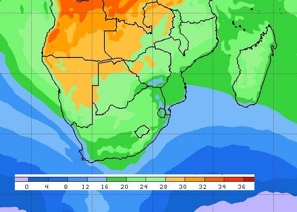
First Visual: Surface (925mB) temperature outlook for Sunday 17 June at midday
Source: Climate Prediction Centre, NOAA, www.cpc.ncep.noaa.gov/products/international/cpci/data/12/fcsts_safrica.shtml
Second Visual: Synoptic map of surface pressure (isobars) early Friday morning 15 June
Source: South African Weather Servivice, www.weathersa.co.za/observations/synoptic-charts
What Happened
The second visual, the South African Weather Service’s daily synoptic map, shows convincingly that the weather pattern is now firmly established in a classic winter stance.
The first visual shows the contrary, but at the same time a typical winter occurrence – despite very low temperatures south of the continent, its unique topographic features, and its position relative to the equator, lead most of the time to pleasantly warm afternoons over the Namibian interior.
The week started with a typical anti-cyclonic circulation over the Namibian interior with a predominantly north-easterly airflow. The inland barometric pressure was a mild 1020 mB during the days with a balancing 1016 mB pressure at the coast. Hence not a large pressure differential indicating the absence of windy conditions and Oosweer. Even the north-western corner of the Kunene region was relatively quiet.
During the first half of the week, a strong frontal system approached the Western Cape but it was deflected by the continental circulation up to Wednesday night, when the jetstreams driving the entire front became too strong, overpowering the continental high and sending a rain-bearing system over the narrow Cape coastal plain and into the adjacent interior. That system extended so far north on Thursday that it reached Lüderitz and inland covered the Orange River valley up to the Fish river confluence in a blanket of fast-moving clouds bringing in cold and in places wet conditions. Remnants of the system still showed on satellite images by Friday morning.
The rest of Namibia, however, enjoyed mild to warm sunny days despite the rapid fall in temperature on Thursday. These cooler night conditions even affected the northern regions, southern Angola and Western Zambia. Katima Mulilo went as low as 2°C, amplified in the lower areas by the quiet conditions. (Windy conditions tend to raise the temperature slightly as it prevents cold air to settle.)
Noteworthy was the absence of Oosweer conditions mostly as a result of the balance between the strength of the South Atlantic high, and the continental high that lay prominently over the central part of the sub-continent. This same inland high also prevented local temperatures to go below zero although the frontal system had all the qualities to bring frost to the Karas region.
All in all, a very typical winter week with clear indications that the coldest part of winter will only come after the solstice on 21 June.
What’s Happening.
The feature to watch on the synoptic map is the large bulge approaching the continent above the low pressure system in the bottom left corner. The bulge is the leading rim of the South Atlantic high. The frontal system south of the high is equal in strength to the one that passed this week, but it is not expected to reach further north than the Western Cape.
The reason can readily be seen on the map: The South Atlantic high will slip over and across South Africa, effectively buffering the rest of the sub-continent from the intense cold behind the front.
As a result (corroborated by the NOAA temperature forecast, second visual), winter conditions will continue during the weekend and into next week. The nights will be cold but the afternoons mild to warm.
The airflow will be predominantly north-easterly bringing in warmer air during the day but quickly being displaced by colder air from the south, the moment the sun sets.
The Karas region will be markedly colder than the rest of the country on Monday, Tuesday and Wednesday but frost is not expected.
By Wednesday, the continental high is still in its position over Botswana but the South Atlantic high is very close to the Namibian coastline. A weak trough will form between the two highs running from the Kunene Region to the south-east across the interior to the Karasburg district. This may bring in some high level clouds but the high pressure control on the surface will be too strong to allow any solid cloud built-up. The wind will be north-westerly.


