


Weather 11 March 2016

What Happened
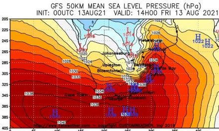
This week’s weather closely followed the pattern similar to 10 days ago. The only exception is that the South Atlantic high pressure cell has grown in strength, reading 1028 mB by the middle of the week. This same pattern is set to repeat itself for the third time over the coming fortnight.
For some time (two months), the core of the South Atlantic high has shown enhanced mobility, shifting from the Lüderitz latitude southward by about 1000 km to 40oS with every passing cycle as it traversed the ocean south of Cape Agulhas. While the proximity of the high has had a negative impact on our rainfall season, this regular shift created a window of improved conditions for local rainfall, every second week which lasted for about four days. Still, the rainfall remained disappointing, mostly due to the height of the mid-level trough that regularly ran from southern Angola through Namibia and Botswana, into South Africa.
Two weeks ago, these conditions started changing noticeably with the core of the South Atlantic gaining strength and displaying a bias to move further south in its decad oscillation. Its eastward protrusion also remained stationary south of Cape Agulhas for longer periods.
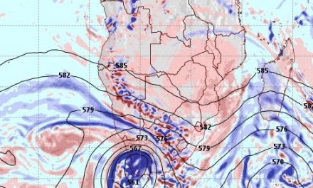
During the week, the customary mid-level trough was present from Angola across Namibia and into South Africa. But on the surface, most of the country was under high pressure control, so the system moved east fairly quickly taking the major rainfall activity to Botswana, Zimbabwe, South Africa’s Limpopo province and southern Mozambique. Yet, while the system was over northern Namibia, it produced some spectacular precipitation.
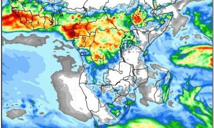
Towards the end of the week, high pressure control has taken hold of most of Namibia at the surface level. This impact could be discerned readily on satellite images, showing that the band of atmospheric instability lay just north of the Angolan border and just east of the Botswana border. Only the Kavango continued to benefit from positive rainfall conditions for the duration of the week.
Over the interior and up to about Tsumeb, the presence of the high was indicated by the cooler nights. Since it is still some two weeks to the equinox, this colder air was rapidly heated when the sun rose, leading and contributing to the expected low-pressure conditions over the central parts of southern Africa.
In the mid-levels, another trough was forming in the wake of its predecessor, again slowly building from the south-western corner of Angola and crossing the Kunene River into Namibian airspace by late Wednesday. This brought in some cloudiness but at an elevated level. It was also noticeable that the colder air penetrated from the south, indicative of the South Atlantic high’s trajectory as it slipped around the continent.
What’s Coming
Chances are very good that the South Atlantic high will again from an elongated, strong protuberance that will stretch from west of the sub-continent to the southern entrance of the Mozambican Channel. Similar to ten days ago, the presence of this high acts as an effective blockade against colder, denser air from the south, while its leading edge, provides the required locomotion from the Mozambican channel across southern Mozambique, Zambia and Angola, and from there into Namibian and Botswana airspace.
It further acts like a damwall, obstructing the low pressure airflow from the north, causing it to converge over southern Namibia and the Karoo in South Africa. This trough started building earlier in the week already, but by Sunday evening, it should be visible over 90% of the country with the only exception, the central and southern Namib, which will remain subject to high pressure control.
The system builds in strength over the weekend with an intrusion from the north becoming stronger during Sunday night. For Monday, Tuesday and Wednesday, rain is indicated for about two thirds of Namibia, as the trough sweeps towards the south-east. The pattern will be very similar to the previous – higher precipitation in the north, some widespread rains over the interior, and again some good rains along the Botswana border from north to south.


