


Overview for the week and 5-day outlook to Wednesday 16 May 2018
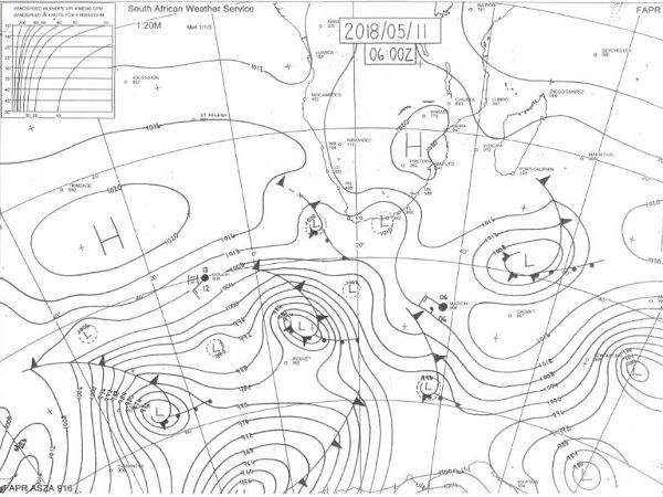
Visual: Synoptic map of surface conditions early Friday morning, 11 May.
Source: South African Weather service. http://www.weathersa.co.za/observations/synoptic-charts
What Happened
A mild cold front passed the Cape during the week but failed to have much of an impact over land due to the presence of the continental high over eastern South Africa and southern Zimbabwe. As can be noticed on the synoptic map, the cold fronts above (north of) 40°S has failed to date to have much of an influence over the bigger sub-continent.
The cold fronts south of 40°S however, are much stronger and better defined with well-developed vortices at their southern ends. These cyclonic vertical funnels tend to siphon away much of the South Atlantic high’s strength as it approaches land, restricting its influence to the area south of the Orange River, and assisting its rapid decay due to solar radiation as its crosses the sub-continent from west to east.
These conditions create a unique weather pattern in Namibia which is typical of the transition phase between late summer and early winter. While the synoptic pattern has certainly adopted a more winter-oriented stance, it is still far from a typical mid-winter pattern.
Friday morning’s synoptic map shows a well-demarcated South Atlantic high pressure cell with its outer rim about 300 km offshore Walvis Bay. But the core itself is of moderate strength only, reading a mild 1020 mB. Similarly, the continental high also has a core of 1020 mB, as does the southern Indian high which is just departing the frame south-east of Madagascar.
During the week, in the space between the South Atlantic high and the continental high, a weak convergence zone developed over Namibia’s south-eastern corner but it failed to produce any local precipitation. The same system, however, increased in strength further along its path, producing some unseasonally heavy showers in the Northern Cape, the North-West Province and the central highveld of South Africa.
The most obvious anomaly on the synoptic map refers to the relative positions of the cores of all three high pressure cells. They are all displaced northward by a good 600 to 700 kilometres. At this time of the season, it would be more typical to find these cores on the same latitude as Saldanha Bay, indicating that they must impact local weather further north, more than expected.
In Namibia’s case, there are two distinct elements that originate from the displaced locations of the highs. The first is the persistent north-easterly airflow over Namibia’s northern half and along the Botswana border, and the second is the heavy fog over the central coastline.
In the interior, the observable results are the cold nights with a south-westerly airflow originating from the South Atlantic high, most prominent on the surface, and the second is the quick reversal of airflow to north-east once the sun has risen. This causes cool to cold nights as far north as Grootfontein with warm to hot afternoons covering most of the country above the escarpment.
These see-saw conditions will continue until the highs’ cores reach a barometric pressure between 1024 and 1028 mB, and they revert to their normal positions at about 33°S.
What’s Coming
The outer rim of the approaching South Atlantic high makes landfall during the weekend, bringing colder, wet conditions to the Atlantic coastline as far north as Oranjemund. But very little precipitation will result from this system due to the high pressure control on both sides, west and east.
Some alto clouds may form north of Etosha over Kunene, Owamboland and the Kavango but these will be of brief duration.
While the high migrates across the sub-continent, cooler conditions will be prevalent over the Karas Region but early-season cold is not expected.
From Monday to Wednesday, a low pressure system is present along the central and northern Namib being strongest on Tuesday indicating possible mild Oosweer over the three days, and some dust storms on Tuesday. These conditions are restricted to the coastline north of the Kuiseb.
By next Wednesday, only one forecast indicates some instability over the Kavango but this will be in the form of an inversion layer originating in Western Zambia with limited cloud formation and suppressed convection.


