


The Week’s Weather up to Friday 07 April. Five-day outlook to Wednesday 12 April
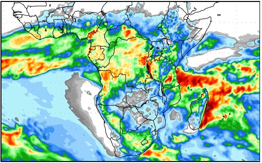
Precipitation forecast from Friday 07 April to Saturday 15 April
Source: wxmaps.org, GrADS/COLA
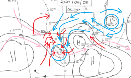
For the first time this season, the core of the South Atlantic high pressure cell reached 1032 mB. At the same time the 1024 mB isobar, the more typical core strength, lay spread over a vast area in the southern ocean. As the week began, the South Atlantic high was still separated from the southern Indian high but during the week, as the South Atlantic high moved closer to the continent, the 1024mB isobar stretched from deep in the Atlantic, some 4000 km west of the continent, to the southern Indian high, some 2000 km east of Madagascar.
In effect this created one huge continuous high pressure cell with three distinct cores. To form a mental image of just how massive and powerful this sedate system is, imagine a bubble running from halfway between Africa and South America, around the southern Cape, and eastwards again to about halfway between Africa and Australia. The three cores lay south-west and south-east of the continent with the third far south-east of Madagascar.
Eventually, by the end of the week, the middle core, about 1000 km south-east of Port Elizabeth, had the biggest impact on local weather. This core drove a pronounced zonal airflow from the southern half of the Mozambican channel, across the sub-continent and into Namibia. The high’s strength showed up on elevation maps with an impact from the surface level up to well above 30,000 feet.
The northern rim of this extensive high pressure system met the tropical system more or less at the Orange River latitude but it was not to be deflected. The cold early mornings with the wind direction from the south-east over most of Namibia south of Grootfontein, was a telltale sign of just how strong the core far to the south was.
The high pressure control on the surface cleared almost the entire subcontinent of moisture until Thursday. Only in the southern Cape a remnant of a trough showed up on satellite images showing a narrow band of cloud.
It was only towards the end of the week, that tropical air from Zambian and Angola managed to penetrate into the Namibian interior. By this time a weak mid-level trough has formed with the customary airflow from southern Angola, across Namibia’s Okavango corner, through Botswana, and into South Africa.
This band of lower pressure brought some cloud to the Okavango regions, the Otjozondjupa region along the Botswana border and southwards into the Karasburg district. Precipitation, however, was scant as the surface high pressure control was too dominant.
For all intents and purposes, this week’s conditions signalled an end to the summer, albeit about one month early.
What’s Coming
As the high pressure cell departs to the east, a moderate low pressure system starts developing as is customary in southern Angola. This system enters Namibia on Saturday, first moving along the coastal plain of the northern Namib but then shifting to the Namibian interior above the escarpment.
In this system, the windflow will be predominantly north bringing in warmer air that should see warmer early morning conditions for at least a week.
The mid-level trough runs from the Kunene Region through Namibia more or less up to Ariamsvlei where it moves into South Africa. During the weekend, the trough becomes stronger, driven by the anti-cyclonic airflow over the subcontinent, the core of which lies over Zimbabwe.
In other words, the seemingly established early winter conditions of the past week, becomes suspended from Sunday onwards, reverting Namibian weather to a more typical summer stance. This system stays in situ for the whole next week.
But because of the dominance of the high pressure system south of the continent, the advection of moisture follows a summer route, i.e. from Angola into Namibia and then into southern Botswana and South Africa. Northern Botswana and western Zambia, and by implication, the Zambezi region, are close to the centre of this anti-cyclonic circulation, indicating these areas will remain dry.
Light to medium showers are expected for Namibia from the Kunene River, through the interior up to the Karasburg district. These conditions set on during Sunday night and continue, off and on, for most of next week. It is only the southern Namib where the likelihood of rain is very slim but do not be astonished if clouds appear in the Sperrgebiet. The airflow from the north is strong enough to make that happen, but it is unlikely that it will produce rain in the desert.


