


Overview for the week and 5-day outlook to Wednesday 21 February 2018
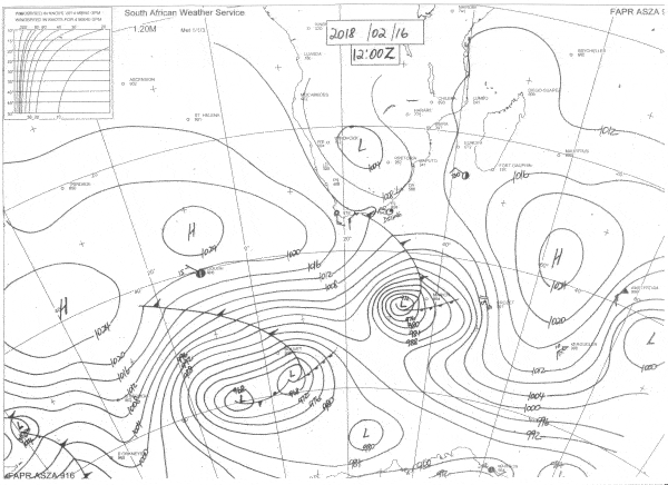
Visual: Synoptic map of southern Africa on Friday 16 February 2018 at midday.
Source: South African Weather Service
http://www.weathersa.co.za/observations/synoptic-charts
What Happened
The mid-level trough of last week lingered over Namibia for the first part of this week. It also formed the tail-end of a rainbearing system that develop far to the west and well below the escarpment. The result was widespread rain over the northern half of the country, and scattered rainfall over the southern half with the exception of the southern Namib.
By Wednesday evening this system has departed to the east with the only substantial rain for the latter part of the week recorded in the areas north of Etosha and Grootfontein, as well as the Otjozondjupa Region along the Botswana border.
While good rains fell in many areas, it is noticeable that the totals are relatively low. Measured rainfall typically came in between 15 and 45 mm but that includes the rainfall over the previous weekend. This is indicative of a relatively weak rainbearing system despite its wide spread. The reason is the level of humidity. While it improved drastically during the 5-day rain window, it never got above 65% which is fairly low for February. This is a result of the fragmented atmosphere over East Africa, blocking or at least preventing the full amount of moisture from the Indian Ocean to reach central Africa.
By the end of the week, as shown in the synoptic map, the overall weather stance has reverted to a fairly normal summer picture. The only significant aspect is the growing strength of the continental low pressure system with its core over north-eastern Namibia, northern Botswana, Western Zambia and the south-eastern corner of Angola.
The synoptic map also shows the weak cold front that passed the Cape on Thursday and Friday. This was corroborated by conditions over the Namibian interior where the early morning temperature on Friday was surprisingly cool. This intrusion of higher pressure was however confined to the surface with little indication of high pressure control in the upper air. The intrusion was also very brief hardly making a dent in the southward migration of the tropical air that originates in southern Angola and Western Zambia.
By the end of the week the core of the Southern Indian high pressure cell lay some 2000 km south-east of Madagascar but with zero influence over the continent where low pressure conditions prevail. The core of the South Atlantic high was some 2000 km west of Cape Town, more or less in its customary position but a few hundred kilometres further north than a week ago.
The outer rim of the South Atlantic high exerted a limited influence over Namibia, clearing the skies and driving the tropical air back to the north-eastern quadrant. This intrusion is expected to last only a few days.
What’s Coming
During the weekend, surface conditions in Namibia is controlled by the South Atlantic high hence no expectation for rain except along the Kunene and Kavango rivers and in the Caprivi. This continues into next week and it is only by Tuesday that conditions are again conducive for rainfall but then only over the northern half.
It is a feature of these low pressure systems that they often developed much further west and south than what rainfall outlooks expect, so there is always the possibility that if moisture is present over the northern half, the system can actually move to the west and along the escarpment to the south. Overall, however, rainfall conditions are not very positive for the next five days and when it rains in the central and northern areas, the falls will be isolated and brief.


