


Overview for the week and 5-day outlook to Wednesday 22 August 2018
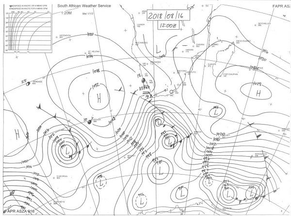
Visual: Midday synoptic map of surface conditions on Thursday 16 August
Source: www.weathersa.co.za//media/data/observation/synoptic/ma_sy.gif
What Happened
Thursday’s synoptic map provides a good point of departure to sequence the week’s weather as it developed from a typical mid-winter stance to a frontal system, the full effect of which is only expected during Friday night.
The outstanding feature of the week was the absence of a well-demarcated continental high. At the beginning of the week, the continental high covered most of the southern and central areas of South Africa even stretching into Zimbabwe, but the usual ridging that pushes back into Botswana and from there to Namibia, did not happen. By Wednesday, the continental high had departed and lower pressures were prevalent over most of the sub-continent.
The continental high is a cell in transition. It originates from the South Atlantic high as it crosses the sub-continent from west to east on its way to morph into the new southern Indian high pressure cell. The continental high tends to linger over southern Africa for no other reason than the unique topography. The relatively high interior plateau limits the immediate effect of solar radiation, keeping the high’s density higher for longer.
Around Wednesday, the synoptic picture was as regular as can be expected for August. The southern Indian high sat south of Madagascar while the South Atlantic high was a few hundred kilometres offshore from the west coast. The continental high was relatively weak with only a small stronger pocket of about 1024 mB across the Lesotho Eastern Cape border. For the rest of southern Africa, it was absent.
The quiet conditions over the interior were also reflected in the 500 mB maps with very little instability in the upper levels. The absence of any active system was mirrored by the pervasive continental haze which is the result of a combination of factors but which is also typical for August. Although there were some wind on the surface, this was not repeated in the levels between 15,000 and 30,000 feet. At these levels, the picture was fairly static.
Conditions started to change perceptibly during Thursday. The southern Indian high was then located about 1000 km south-east of Madagascar and the continental high has all but collapsed. The South Atlantic high made landfall between Saldanha Bay and Port Nolloth, and fresh southerly winds blew across the Orange River. As can be seen on the visual, a strong 25 knot wind whipped Lüderitz and the Sperrgebiet, showing up on satellite images as large areas covered in dust.
This intrusion penetrated the Namibian interior from the south-east and Friday morning’s temperatures were notably cooler than the previous four days. Across the Hardap and Karas regions, night temperatures dipped to around 5°C. The cooling effect reached right up to the northern region where the night cooled to about 12°C.
What’s Coming
During Friday, the core of the South Atlantic high has moved over land, covering the areas south of the Orange River latitude. There is a small section, mostly the Karasburg district, where some ridging occurs leading to a cold Saturday. For the rest of the country, the coolest temperatures will be felt along the Botswana border but this is very typical for August. Windiness picks up somewhat in the wake of the high with continental haze being present again during Saturday.
The high departs rapidly and by Sunday it is back to a balmy winter’s day for most of the country above the escarpment. A weak mid-level trough forms in its customary position from south-western Angola through Namibia into the South African interior. This may bring windy conditions to the northern Namib and the central plateau but the leading outlooks do not concur on this.
Next week is generally expected to be cooler than this week, but the overall pattern and progression will be a repeat of this week’s conditions. The next South Atlantic high approaches the continent by Sunday evening and Monday may hold a bit of a cold surprise for Oranjemund, Lüderitz and the Karas region near the Orange River.
A fragmented cold front is expected to pass the Cape during Monday but its effect is unlikely to have a strong impact in Namibia. Local weather is in that typical see-saw pattern nearing the end of winter. While cold intrusions may surprise, they are limited and very brief.
Namibia’s northern two thirds will be warm to hot with much haziness in the early mornings.


