


Overview for the week and 5-day outlook to Wednesday 07 March 2018
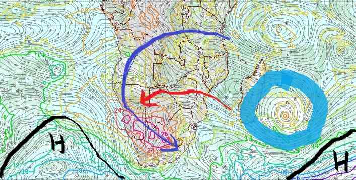
Visual: 850 mB outlook for airflow and relative humidity on Monday 05 March
Source: GrAds/Cola – George Mason University, http://www.wxmaps.org/fcst.php
What happened
A very well developed system of lower pressure covered about two thirds of the entire southern Africa, reaching from Mozambique across South Africa and Botswana into Namibia. This vast area was marked by moisture throughout the atmospheric spectrum, from about 1000 feet above ground level up to 35,000 feet.
Such low level cloud made flying a daunting prospect with many pilots complaining about the low cloud base, especially in South Africa with its heavy air traffic. On the Namibian side of the sub-continent, the impact from the South Atlantic high pressure cell was notable, and from the air, it was fairly obvious that the cloud cover became scattered the closer one flew to Windhoek.
On its western side, this vast system spilled over into Namibia’s northern half, with particularly good convection from Grootfontein further north, and into Bwabwata and Zambezi. With such vast amounts of moisture in all layers of the atmosphere, precipitation in the north-east was widespread and of high intensity. The highest concentration was in the Chobe region in Botswana which saw most of the rainfall.
Over the Namibian interior, the effect of the South Atlantic high pressure cell was evident. While cloud formed readily in the middle levels between 12,000 and 18,000 feet, the rainfall over two thirds of the country was again rather disappointing.
This was most noticeable over the southern half where cloud formation was weak or absent, with high level ridging which led to excruciatingly hot afternoons for the second half of the week.
In the map above, the position of the South Atlantic high and the southern Indian high are marked in black. East of Madagascar is an intense tropical storm marked in blue. The core of this storm is currently moving from north to south some 500 km offshore the Madagascar east coast. The map is the outlook for Monday so it is only in another three days that these conditions are expected to transpire.
There are two routes that moisture typically follows from the Indian Ocean to Namibia. The first and the most conventional is the long route, marked in dark blue. This is typically an 8 to 10 day journey as conditions are generally more sedate over central Africa but this is the way that most of Namibia’s rain reaches its end destination. The route marked in red is the short route and this happens only by exception. Still this short route has the opportunity to bring short rainfall windows to Namibia but with higher intensity. Such a window is opening up on Monday.
What’s Coming
Conditions over the weekend are a continuation of what happened this week. The Hardap and Karas regions will still suffer high level ridging so the very hot days will continue. Meanwhile, the South Atlantic high migrates around the southern tip of the continent, starting to blow from south to north in the Mozambican channel. Coupled with the enormous amount of moisture elevated into the atmosphere by the tropical storm marked in blue, the short route becomes very active.
As from Monday, there is a very good chance that the airflow from the east, amplified by the push from the high, will cross the entire Namibia from east to west, at least up to the escarpment.
This system may even penetrate the coastal plain over the northern Namib and if it grows to its expected strength, it will move far to the west and south.
The consensus rainfall outlook is for widespread rain with scattered showers over the northern half of Namibia on Monday, Tuesday and Wednesday and for isolated showers over the southern half except the southern Namib.


