


Overview for the week and 5-day outlook to Wednesday 07 February 2018
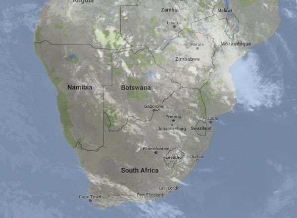
Visuals: Satellite image of southern Africa at 11:00 on Friday 02 February 2018
Source: Space Science & Engineering Center, RealEarth Imagery, University of Wisconsin – Madison http://realearth.ssec.wisc.edu/
What Happened
This week’s progressive weather development offered a treat for physics geeks as it demonstrated in very practical terms the so-called Coriolis Effect. Amplified by the inputs from both high pressure cells that normally lie east and west of southern Africa, it is this phenomenon that causes the general air circulation over the mainland to be anti-cyclonic.
Southern Africa’s anti-cyclonic circulation can vary quite a lot in intensity, but it is almost always present. It is the mechanism that advects air from the Indian Ocean in a wide arch into central Africa and from there into Angola and Namibia. The system was very intense this week with the result that much moisture entered Namibian airspace, visible on a daily basis as substantial cloud cover over very vast areas east of the escarpment.
From local weather station readings, it could be seen that humidity over the northern half of Namibia was the highest so far this season, reaching 50% in some place and averaging above 40% in most.
The image above shows the southern African subcontinent with substantial moisture across central Mozambique, Zimbabwe, Western Zambia and southern Angola. A mid-level trough runs through Namibia’s interior into Botswana which is the typical weather stance for this part of the season. The location and depth of the cloud cover are determined by the relative position in the very large “wheel” of circulating air driven by the anti-cyclonic circulation.
This wheel also has a core, similar to the cores of the high pressure cells, and the position of this core is crucial to

determine rainfall prospects over Namibia. As can be seen from the second image, on Friday the core sat over Beira in Mozambique. For the duration of the week, it has meandered from Western Zambia into northern Zimbabwe and later into central Mozambique.
The ideal position for this core is at the confluence of the Limpopo and Sashi Rivers on the Botswana Zimbabwe border. When the pivot of the anti-cyclonic circulation gyrates around the Sashi River, Namibia has the biggest chance for good rains.
However, as always, the strength and impact of the South Atlantic high pressure cell must not be underestimated, especially its influence on the lower atmosphere from ground level up to about 12,000 feet aloft. This was also visible on satellite imagery with open skies in the north-west, the central and southern Namib, and most of the Karas Region.
What’s Coming
Rainfall prospects are now improving by the week. This is witnessed by the position of the southern boundary of the Inter-Tropical Convergence Zone which is above the Namibia Angola border.
During the weekend, lower pressures are present over Namibia and Botswana and moisture continues to intrude from Angola.
The customary mid-level trough is in place from Angola across Namibia into the Northern Cape, and the convergence zone is expected to shift west. All rain forecasts expect light to medium precipitation on Saturday and Sunday for the whole country except the Karas Region.
For the first time this season the ITCZ is expected to wander into Namibian territory during Tuesday and Wednesday next week albeit a limited intrusion of only about 100 kilometres in the West Kavango between Rundu and Nkurenkuru.
The system persists for Monday to Wednesday with the bias shifting to the west meaning that widespread showers are expected above the escarpment with some light rain on the coastal plain below the escarpment.
Rainfall conditions have markedly improved compared to a week ago.


