


The Week’s Weather up to Friday 27 October. Five-day outlook to Wednesday 01 November 2017
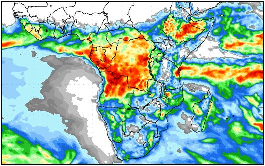
Map: Rainfall forecast from Friday 27 October to Saturday 04 November 2017
Source: COLA/George Mason University
http://www.wxmaps.org/outlooks.php
This week saw the first significant showers in the north. Widespread rains were observed from Sunday to Wednesday in Ohangwena, Oshikoto and Kavango East regions.
Cloud built-up started during the weekend and by Sunday afternoon the first showers appeared in a wide belt from Omuthiya eastward to the Kavango East border.
The rainfall was so substantial that puddles formed extensively over large areas although none of these kept the water for more than a few hours after the actual showers. However, the four-day presence of the clouds indicated a much bigger system, exceeding the boundaries of Namibia.
Satellite images revealed that this was indeed the case. While the South Atlantic high pressure cell did not make landfall during the week, its offshore presence was strong enough so that its outer rim effectively spread to the Orange River latitude. This had an impact on local weather as witnessed by the continuation of cool nights for the entire week.
In the north however, a low pressure system dominated with a pronounced north-east to northern airflow. This, in turn, was reflected in the very hot days across the entire northern border from Ruacana in the west to Katima in the east, a distance of more than 1000 kilometres.
This is a typical early-summer pattern with the last vestiges of winter conveyed by the South Atlantic high in the south-west and the first prominent intrusion of tropical air from the north driven by the anti-cyclonic circulation over the sub-continent.
The colder, denser southern air encounters the lighter, warmer northern air along a very wide battle front stretching from southern Angola, through Namibia and Botswana into the South African interior. The colder air hugs the surface while the warmer air tends to rise, thus the northern system pushes over the southern system while the jetstreams in the upper air, above 45,000 feet, shifts the entire system from west to east.
Where the two systems overlap, a so-called convergence zone forms, within which the airflow is from north-west to south-east. The edge of this zone is clearly visible as the relatively straight line where the clouds stop. This is a Namibian trademark that can often be observed over Windhoek.
At the beginning of the week, the convergence zone was located relatively far eastward, lying over south-eastern Angola, Zambia and Botswana. By Wednesday evening, when the continental high has departed to the east, the system started shifting to the west and significant cloud built-up could be seen by Friday.
A strong frontal system, although the core remained offshore, still passed within 100 km of Cape Agulhas on Wednesday. This was the leading edge of the South Atlantic high as it moved to the east, impacting the sub-continent south of the Orange River. It is the departure of this system that allowed the convergence zone to shift from Angola/Botswana into Namibian airspace.
What’s Coming
Another prominent feature of this week’s weather was the reduced number of clearly defined high pressure cells in the southern hemisphere. By the end of the week there were only four. This implies large distances between the cores, often thousands of kilometres, which create space and opportunity for tropical air to move southward in the wake of the trailing edges of the highs.
With the departure of the high, a similar situation developed over Namibia.
The north to south airflow continues during the weekend while the next South Atlantic high is still some 2000 km offshore. Ahead of the high is a significant low pressure system which will amplify the advection of warm, moist air from the north. This does not show before Sunday when large cloud formations will start moving into the interior from the north.
Given the large distance before the next South Atlantic arrives, a four-day window is created during which conditions are positive for rainfall.
The question is, How far west will the system develop? According to the forecasts, the rainfall bias is over the western half of Namibia from the Kunene to the Orange. On Monday and Tuesday, the coastal plain is still excluded but by Wednesday, rainfall is expected across the entire country except the coastal plain of the southern Namib.
It is indeed the first time this season that rainfall is forecast for four days, and for most of the country.
Note that the rainfall forecast map can be misleading. It shows the accumulated rainfall over eight days so local falls can be very slight, but when these are repeated over several days, the totals become significant, which is what the map indicates.


