La Nina returns to the Pacific
During November and December, atmospheric conditions over the equatorial Pacific changed from neutral to a weak La Nina, with current forecasts favouring a stronger La Nina until March.
The dominant La Nina during the early part of last year lead to above average rainfall across most of Namibia except the east and north east. Rainfall was so enhanced it set many new records.
Then in May, the Pacific La Nina subsided, local rain stopped, and was abruptly followed by a long and relatively cold winter. So-called ENSO (El Nino Southern Oscillation) conditions were neutral.
Towards the end of the year, instead of swinging to El Nino, La Nina returned but in a much subdued form.
A changing climate, by definition, implies that many of the previously accepted benchmarks for ‘weather’ have undergone at least a shift of stance, if not an actual change of direction.
The Pacific Ocean, in particular the mid-Pacific, is no exception. Because of the significant role which this narrow band of water, the equatorial belt, has on weather/climate worldwide, such departures from these benchmarks both maintain an effect on the day-to-day weather and on the weather for an entire season.
Over the past six years, the mid-Pacific switched three times form El Nino to La Nina with only very brief spells when conditions were neutral.
During these past half-dozen years, the effect of the changing climate has seen a departure from the accepted synoptic norm: where sea-level anticyclonic cores parade along the 30S latitudes. In an almost annually predominant pattern, these cores have been found some 10 degrees further poleward (40S): prior to the identification of “climate change” this was an axiom for a La Nina identity.
While this can look interesting when seen on a synoptic map, this disposition gives a practical base above colder waters for higher core pressures: 1040hPa or higher, on a repetitive basis and correspondingly increased, strengthened, outflows from these pressure cores: Trade Winds.
Stronger Trade Wind flows have been identifiable even during the 3 intervening ENSO events.
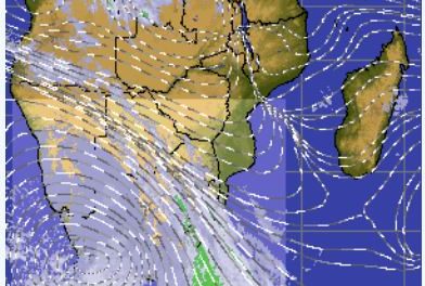
During the La Nina’s the effects have loomed large and strong on “weather”. Where, in particular, Namibia has been concerned, this has meant increased intensities of rainfall events, from daily measures to clusters of days throughout the course of the (each) individual season.
An effect of a changing climate has seen an increased ability for Inter-Tropical Convergence Zone activity to dominate part of the southern African weather scene. In particular again, this has been readily identifiable across Namibia and with increased rainfall totals and individual intensities.
This last season saw an intense La Nina event (international commentaries) with record-breaking results on our rainfall statistics.
The event was deemed to be “fading”, at least, by the published commentaries. But as interested spectators will surely have noted, the synopses of the South Pacific Ocean have persisted with the La Nina-favourable pattern. Trade Wind flow towards the Equatorial Pacific from resiliently strong anticyclones persisted accordingly. A similar stance has largely survived around the entire hemisphere: the resultant north-south-north flow provided polar inflow during the winter months and will, just as it has provided in past seasons, ensure cooler, moist inflow occurrence in the forthcoming months. The forthcoming months imply, specifically, the (our) rainfall season/months.
Does this mean yet another generally positive rainfall season for Namibia in general? Although such commitment is usually best done from a guarded stance, in my view a wetter outlook is justifiable but it will be delayed by at least a month.
By comparison with the international weather scene, this opinion marches in steady time with the records of (at the very least) the declining summer rainfall patterns across the northern hemisphere. ITCZ ranges of activity have extended further north than the “normal” (again), rainfall intensities have provided floods even to the level of widespread inundation (again). This was forcefully demonstrated earlier this week when places in Alaska were literally snowed under with 5 metres of snow.
From the immediate history of our preceding seasons, the outlook for a Cuvelai delta efundja of some duration as well as surging occasions (days to weeks) in all the northern cross-border catchments is a strong possibility.
From the stance as seen across the past few months north of the Equator, there is a possibility that the peak of the season maybe rather late.