The Week’s Weather up to Friday 25 August. Five-day outlook to Wednesday 30 August 2017

Graph: El Nino Southern Oscillation forecast ensemble to May 2018
Source: Update as at 21 August 2017 prepared by:NOAA, Climate Prediction Center / NCEP
Over the past two weeks, the sea surface temperatures in the eastern and central Pacific have moved into a well-defined La Nina stance. This has prompted the Climate Prediction Centre in the USA, in their latest update to forecast below-average Pacific temperatures up to May next year.
Lower temperatures in the Pacific have in the past always translated into above-average rainfall for Namibia.
The Pacific stance is corroborated by the 30-day Moving Southern Oscilation Index maintained by the Australian Bureau of Meteorology. This index shows the difference in barometric pressure between Tahiti (middle of the Pacific) and Darwin in Australia (western Pacific rim) some 1000 km away. When the sea surface temperature differential is bigger, i.e. colder water in the mid-Pacific versus warmer water at the Maritime Continent, compared to conditions one month ago, then the index reads positive. It has moved into positive territory during the first week of August.
This is not an indication of a La Nina. These conditions have to be empirically replicated for at least six months before a La Nina is declared officially. Rather, one can define it as a normal, but short phase in the annual oscillation between summer and winter in the southern Hemisphere.
As can be seen from the graph, the Climate Prediction Centre does not expect sea surface temperatures to go below the 0.5°C anomaly except briefly in December this year and January next year. It is still too close to the threshold and of a too brief duration to come near a proper La Nina.
Yet the temperature in the eastern Pacific has already breached the -1°C anomaly and with strong easterly winds in place, it it reasonable to assume this colder water will eventually be driven to the central Pacific and even have an influence in the western Pacific towards the end of the northern hemisphere winter.
Therefore, in a nutshell, the forecast ensemble is probably a fairly reliable indicator of what will happen in the Pacific. The expectation that this short (almost) La Nina phase will bring wetter conditions to Namibia is pure assumption however and must be handled as such. Much more depends on the condition of the so-called Indian Ocean Transport to have an impact on local weather than on the Pacific but the corrolation between La Nina and higher precipitation in the western half of southern Africa has been shown historically.
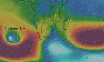
This week marked another typical late winter stance in Namibia still under high pressure control, both on the surface and in the upper levels. Despite two weak cold front passing the Cape, the presence of the extended high pressure cell north of them, prevented more than a superficial, very brief intrusion.
The familiar see-saw weather pattern, explained in previous articles, is all too obvious, i.e. cold nights with warm days, the cold conditions migrating from west to east in the Karas Region, and then a day later, from east to west in the Kalahari and northward along the Botswana border. This movement depends on the position and relative strength of the South Atlantic high pressure cell as it approaches, makes landfall and then curles across the sub-continent from west to east and then back again as it follows the anti-cyclonic circulation prevalent further north.
What’s Coming
The winter has been anomalously warm as can be seen from several land surface temperature maxima and minima charts. These conditions continue during Saturday.
By Sunday, two prominent low pressure areas are expected to develop, on in the North straddling the Namibia Angola border and the other just south of the Orange River Valley.
The low pressure in the North is the result of solar heating over the flat Owamboland plains. It will continue throughout the next five day meaning the days will be hot, especially in the afternoon with only a hint of a breeze.
The low pressure system in the south will bring windy conditions to the Karas Region on Sunday night and Monday but it moves away towards the east within a day. By Tuesday, conditions in the South should be back to normal.
For the duration of next week, the 1016 mB isobar is forecast to sit on the border between the Karas and Hardap regions. This indicates that there will be a noticeable difference in weather between Namibia’s southern half and northern half. The southern regions will continue with the late winter pattern while the northern half will see early summer conditions, even with some clouds from Wednesday onwards.


