


Overview of the past two weeks up to Friday 19 July and short-term outlook to Wednesday 24 July 2019
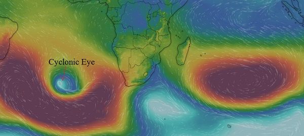
Visual: Computer generated synoptic map for the South Atlantic, southern Africa and the southern Indian Ocean as on 19 July.
Source: https://www.windy.com/-Show-add-more-layers/overlays?pressure,-17.225,49.570,3
Recent Development
Local weather is caught in that midwinter lull when the synoptic progressions are fairly predictable with intermittent high pressure cells crossing southern Africa from the Atlantic to the Indian Ocean on their predetermined route from west to east.
For the second week in a row, the same general conditions have held sway. As can be seen on this week’s visual, the pattern is typical mid-winter with the southern Indian high pressure cell, east-south-east of Madagascar and a weaker extension back to the continent, but the island also shielding the Mozambican Channel to a large degree.
Over the Atlantic, the high pressure cell covers almost the entire distance between South America and Africa, indicating that high pressure conditions will control local weather for at least another two weeks.
The feature to watch is the blue spot indicated on the visual as a cyclonic eye. This vortex is certain to have an impact on Namibia’s weather but only in about four days from Friday, i.e. its influence will be felt by next week Tuesday night and Wednesday, possibly lingering into Thursday.
It is also important to note that the core of the southern Indian high is located more or less on the regular winter latitude (33°S) but that the South Atlantic high is displaced to the south by roughly 600 kilometres. The visual also shows that there is a surface impact on Namibia of colder air, which is expected to intensify as the leading rim of the high moves around and across the southern Cape.
Except for one brief cold spell earlier in July, the current season has not produced much in terms of winter events. The closely successive highs are the reason. Although their leading rims advect cold air from the south, the northward intrusion is obstructed and to a certain extent blocked by the anti-cyclonic circulation over the sub-continent itself. This circulation, in turn, is caused by the departing rim of the previous continental high which has in the mean time morphed into the new southern Indian high.
When the distance between the trailing rim of the departing high and the leading rim of the next approaching high is relatively small, there is little room for any so-called window between the two, meaning that any cold intrusion is very limited, both in terms of duration and extent. These conditions, although causing quite cold conditions in the Western Cape, hardly get the chance to cross the Orange River so their effect is limited to one, or at most two cold, windy days at Oranjemund, Lüderitz and Aus. Inland the effect may spread to the Fish River where it joins the Orange but that is about it.
Further north, over the Namibian interior, the advance of cold air is halted, preventing frost, and it is usually only a day later that the cold air penetrates from the east, across Botswana, as the high’s core shifts its position to the east.
On the Radar
Overall conditions are set to remain relatively static for another week with cold nights and warm afternoons. This see-saw play-off between weather influences from the south-west (Atlantic) and the north-east (sub-continent interior) are set to remain until the positions and the strength of the high pressure cells change, which will only happen later in August.
The cyclonic vortex will make landfall along South Africa’s west coast during Tuesday with the expectation for very wet and windy conditions up to Port Nolloth but in Namibia it will be restricted to the southern Namib, the escarpment, and perhaps a little into the interior. It will however bring cold air into the interior from the high behind it, and that will lead to very cold early-morning conditions on Wednesday and Thursday.
The Karas region may see a lot of mid- and upper level cloud on Wednesday and possibly Thursday, with a reasonable chance for light precipitation over the Sperrgebiet.
The rest of Namibia will continue with the regular, static mid-winter stance: cold nights up to about Grootfontein, warm days, especially the afternoons over the interior, hot afternoons in the north, weak Oosweer over the coastal plain due to the easterly windflow, and heavy fog from Swakopmund northwards.


