Understanding Weather – not predicting – 07 Septmber 2012
What happened?
As the new season emerges, warmer patterns become more obvious where the local weather is concerned.. This emphasizes not only the size of the sub-continent, but also the ability for several varying weather patterns to prevail more or less along side each other. Really, there is nothing “new” about this sample of sub-Tropical High Pressure Belt weather, but across recent seasons, this feature has been accentuated. A cause for this departure from the expected stance is that there is a lot of characterized geography giving its emphasis, to the passing weather show. This ability is latent, it can often be over-ridden or excluded from analyses, but over the longer cycle of an entire season, the unique southern African topography has an influence on weather patterns that can not be ignored.
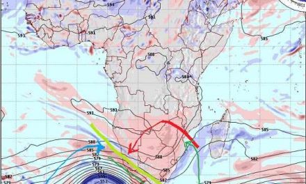
The “big” weather map is that of the Mean Sea Level synopsis. The usual pressure base is the 1000hPa level. This is in itself at a level different from our prevailing pressures which usually are about 1020hPa. Advancing inland, the level quite abruptly ascends through the 925hPa chart to the widely used 850hPa level. Sometimes these can be in tandem, featuring compatibility with matching weather patterns, on other occasions the divergence is remarkable! To tease the imagination, there are 2 levels further aloft ready to make or break emerging synopses: and do so!
The inland, elevated, plateau also hosts various mountain ranges, even at intersecting angles: if you are in Windhoek, look out of a nearby window to verify. These various features frequently impose weather pattern variation within eye-sight range. From the wide range of charts, synopses and all that there are available daily, one is made aware that our sub-continental interior can be merged with the surrounding maritime expanse so that expected weather will vary: wind flow in particular.
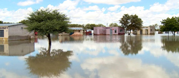
The meteorologist/geographer will advise that these probabilities all match the expectation of “variability” as part and parcel of our weather world. The front page photograph of last week provides a positive example, too. Weather headlines from eastern parts of South Africa these past few days equally exemplify this variability: although rain, quite heavy rain, is possible its occurrence will always attract attention since the late winter/early spring is not the “normal season” for such extreme weather events
Closer to home though, such drama has absented itself; for yet another week, clear sunny days predominated: mild at night, warm by day, hot though in the north.
What’s coming?
Overall, scant change is expected as successive patterns develop then swerve away round the Cape during the weekend. Generally quiescent conditions prevail, but in such dry air, veld fires are to be expected. Day maxima approach the 30’s , above in the north; cloud intrusions remain in the future.
The Indian Ocean high pressure area has its core south of Madagascar. As the season progresses, this high pressure cell extends its influence over the sub-continents, offsetting the dominant winter flow from the South Atlantic high. The battle between these two cells determine the short-range local weather. Neither rain nor frost is expected, either North or South. Wind flow will remain north easterly, gradually setting the stage for the Inter-Tropical Convergence Zone to wander southward and herald the new rain season.