


Overview for the week up to Friday 08 June 2018 and 6-day outlook to Thursday 14 June
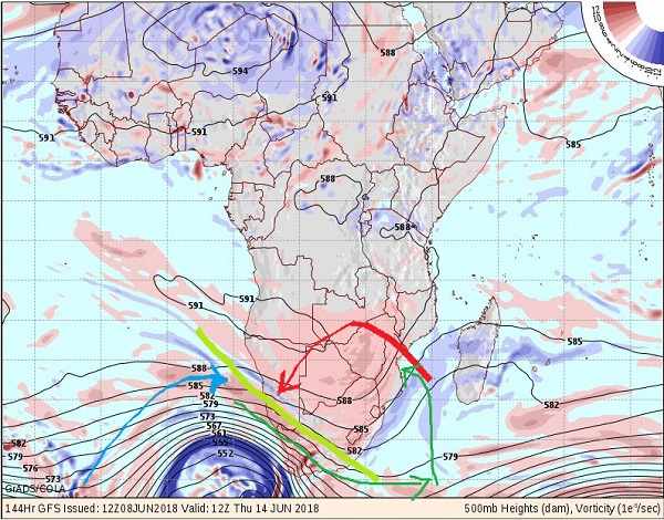
Visual: Vorticity outlook at 500 mB (+-18,000 feet) for Wednesday 13 June
Source: GrADS/Cola, George Mason University, http://www.wxmaps.org/fcst.php
What Happened
This was a high pressure week with only a weak low pressure system on the coastal plain in the northern Namib. Barometric pressure on Thursday over eastern Namibia, Botswana and the Northwest and Limpopo provinces in South Africa went as high as 1024 mB. On the northern rim of this continental high pressure cell, a strong zonal circulation from east to west followed.
It was an exceptional week in the sense that local conditions were mostly influenced by close regional weather. It is more typical that Namibian weather is the result of weather developments very far away, sometimes thousands of kilometres, and often far out to sea, both in the Atlantic and in the Indian Ocean.
Most noticeable at home was the quiet sunshine days, relieved at night by some windiness. However, the dominant wind direction over the interior consistently remained easterly. This produced the typical cold nights and warm afternoons that is a standard feature of the Namibian winter.
With a barometric pressure of 1024 mB over the interior and only 1016 mB over the northern Namib, it created a considerable pressure differential. The natural result is that air flows from the higher pressure area to the lower, in our case from the interior to the coastal plain. This movement of air is further amplified by the strong zonal push from the east as a result of the general anti-cyclonic continental circulation.
The next feature that then comes into play is Namibia’s unique topography. The interior plateau lies at an elevation around 1600 metres while the coastal plain cover the area from the sea (0 metres) to the western face of the escarpment (300 metres). What then happens, like this week, is that the air descends horisontally by around 1300 metres. Sinking air is typical of high pressure cells, so the dense cold air, moving towards the west, naturally descends the moment it crosses the escarpment, falling onto the coastal plain, in a manner of speaking. As it does, two things happen, it picks up speed, moving faster to the ocean, and it compresses.
As it picks up speed it leads to windy, dusty conditions along the coastline. The closer to the coast, the more severe these conditions become. And as it compresses, it releases energy the same way a valve heats up when one inflates a tyre. It is called diabatic compression. This raises the ambient temperature, and in our case considerably due to the large horisontal distance the air sinks (1300 metres). We call it Oosweer and it occurred in abundance and in strength this week.
Oosweer conditions started on Tuesday in the central Namib but there are very few people there to record it. It then quickly spread north and intensified, engulfing Walvis Bay, and then moved gradually up the coastline until it also covered the south-western corner of Angola. Satellite images clearly showed the dusty conditions, starting at the Kuiseb and intensifying the further north one looks with the strongest winds and most dust in Angola.
What’s Coming
The visual chosen for this discussion is the outlook in the middle levels of the atmosphere for next Wednesday. The blue arrow shows the approach angle of the South Atlantic high pressure cell. Ahead of the cell’s outer rim, is a very strong frontal system, terminating in a vortex at its southern end. This system has its biggest impact on the surface, gradually weakening as elevation increases.
The red arrow shows the anti-cyclonic continental circulation, also with a strong surface impact. These two systems (blue and red) oppose each other. Where they meet, a convergence line is formed (olive green line) with the Atlantic high tending to hug the ground, while the somewhat warmer airflow from the interior tends to rise and slip over the high pressure cell.
The continental airflow is a barrier to the onslaught of the South Atlantic high. The result is deflection. This is indicated by the lower verdant line and causes the frontal system to be deflected to the south, but in the meantime, the entire system and the convergence zone, are relentlessly pushed to the east by the strength of the South Atlantic high. The vector that results sees the frontal system deflected to the south and slipping around the Cape, or only covering the southern and Eastern Cape areas.
If this system develops as anticipated, it will make landfall in Cape Town, next week Thursday during the night. It is such a strong system, it will have a northern extension that may reach all the way up to Lüderitz. The second verdant line is the direction in which the system will move around next weekend.
Before that happens though, Namibia will experience three to four (Sunday to Wednesday) generally warmer days since the airflow will be dominantly north to south ahead of the frontal system.


