


The Week’s Weather up to Friday 16 June Five-day outlook to Wednesday 21 June
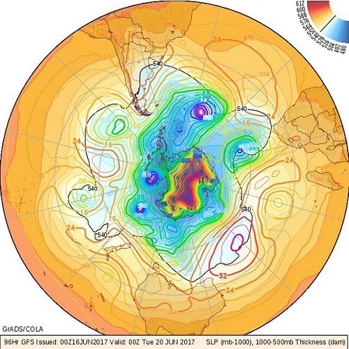
Southern Hemisphere barometric pressure for Monday 19 June 2017
Source: wxmaps.org, GrADS/COLA
The selected map for this week’s weather discussion is the pressure forecast for next Monday, 19 June, showing a marked difference between expected conditions for next week, and this week’s weather.
During this week, two single cold fronts and one linked front crossed south of Cape Agulhas. However, as was expected, the impact on Namibian weather was minimal. Over the largest part of southern Africa, high pressure conditions reigned with a weak anti-cyclonic circulation on the surface, and a more pronounced zonal, west to east, airflow in the upper atmosphere.
The result was a typical see-saw mild winter pattern over Namibia. Very little wind was evident over the interior. On the coastal plain, it was the customary late afternoon, south-west to south, inshore wind. Above the escarpment, nights were cold with a marked airflow from the south-east but less than one hour after sunrise, surface temperatures were above 20°C and the wind backed to a north-easterly direction
This is the result of the interplay between the very delicate pressure differential between the northern (tropical) and the southern (antarctic) systems. It is typically a feature when the difference in barometric pressures is slight, maybe four thousandths of a bar. The external vector is of course the sun, and given that southern Africa does not extend that far south, the sunshine hours per day comfortably stay more than 10 hours and 30 minutes. This is a lot of energy, enough to have a substantial impact during the day despite the night temperatures plummeting to around 4°C.
This gives us our familiar see-saw pattern during the first half of winter. As soon as the sun sets, solar radiation ceases, terrestrial irradiation is at its highest, the energy in the system drops rapidly, the airmass contracts, subsides and barometric pressure rises. This reduces the differential between continental and maritime pressure, the system equalises and the (cold) impact from the south becomes prominent.
When the sun rises, the opposite happens. The surface temperature rises, the lower airlayers expand, and rise, the barometric pressure drops, and the system tends to equalise with tropical conditions. The airflow now comes from the north-east, the day quickly warms up and by late afternoon it feels like a late-summer day.
This only happens when continental high pressure is in control on the surface, and exerts an influence up to the mid-levels at around 25,000 feet. The technical term is ‘ridging’ and it is a results of static conditions from the surface up to the alto levels. During the day its main features can be observed in clear, blue skies, with very little wind. At night, it is witnessed by the sudden cold, the continuing absence of wind, and the brilliant display of the celestial theatre.
What’s Coming
As can be seen from the map, overall conditions will remain subject to high pressure control.
During Saturday and Sunday, the continental high is positioned over eastern South Africa. This high drives the anti-cyclonic circulation over land meaning the see-saw conditions carry on for at least another two days.
By Sunday evening, lower pressures have set in over Namibia’s coastal plain with more wind but the interior remains calm. A cold front is about one thousand km west of Cape Town but it remains offshore following a trajectory far south of Cape Agulhas.
It is only by Monday that local conditions change with the cold front having moved to about one hundred km south-west of Cape Town, but the so-called 540 dam line, where it is 0°C on the surface, does not make landfall.
As can be seen on the map above, all the high pressure cells in the southern hemisphere are relatively subdued, measuring on average 1024 mB, a very normal core pressure for winter. It is only the southern Indian high that is expected to be somewhat more intense but that will have zero impact on Namibian conditions. The interesting feature to notice on the map is that there are only three prominent high pressure cells around the entire hemisphere. This indicates that the distances between cell cores are exceptionally large, meaning there is ample opportunity for warmer air from the north, to intrude in the wide lower pressure channels between the cores.
North to south airflow will continue over Namibia, indicating that real winter has not arrived yet. Thus, cold nights are to be expected but afternoons will be mild.
Only next Tuesday night will be cold in the south-eastern quadrant and frost can occur in the western half of both the Karas and the Hardap regions. This intrusion is brief however, and by Wednesday, the cold will have departed.
Mild Oosweer is expected for Wednesday afternoon and early evening from Walvis Bay further north but it is restricted to the central and northern Namib.


