


Overview for the week and 5-day outlook to Wednesday 01 August 2018
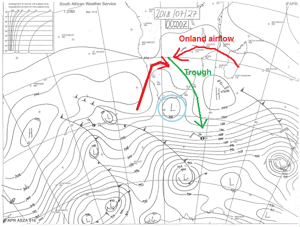
Visual: Synoptic map of surface conditions for midnight 26/27 July
Source: South African Weather Service, http://www.weathersa.co.za/observations/synoptic-charts
What Happened
This was not a very active weather week. Condition were fairly static and predictable with most elements positioned in a conventional synoptic pattern with a distinctly late-winter stance. Without any major intrusions or anomalous events, the only significant change happened unobtrusively and almost unnoticed – the number of sunshine hours reached the 11-hour mark for the Windhoek latitude on Wednesday.
In the first half of the week, the South Atlantic high pressure cell approached the continent but the core never made landfall. It remained offshore about 200 kilometres and only the outer rim, measuring 1020 mB crossed the Western Cape with a fairly restricted impact further northward. As the stronger part of the high at 1024 mB slipped around Cape Agulhas it linked up with the remnant of the departing southern Indian high, forming a weak high pressure zone south of the continent.
Inland, conditions were marked by lower pressures although none of the developing systems could be described as a proper low pressure system. Towards the middle of the week, the high split, the South Atlantic part retracted somewhat and the continental part shifted offshore to a position south of the Mozambican channel. This created the onland airflow indicated in the visual with the red line on the right. At the same time, the still-offshore core of the South Atlantic high moved closer to the Namibian coastline, bring in a westerly to south-westerly airflow over the western half and the southern regions. Where these two systems met, a weak trough formed with a distinct north-west to south-east advection, but this was located over central Botswana and through South Africa, so very little local impact other than helping to siphon cold air away.
The result was a balmy week and as the sunshine hours reached an important threshold, pleasantly warm days were the result. The only exception was Thursday night in the north-eastern quadrant where it was actually quite cold in the Kavango and the Otjozondjupa region along the Botswana border. This was the result of ridging during the night, still visible on the early morning charts, but gone after 08:00 as the trough quickly dissipated the colder air.
By Friday, typical late-winter conditions were present with barometric reading varying from 1020 to 1016 mB, neither high nor low.
What’s Coming
The area to watch is the low pressure system south of Cape Agulhas, marked on the visual with a blue circle.
This has all the potential to develop into a cut-off low and if it does, it will be situated offshore between Saldanha Bay and Port Nolloth.
The core of the next approaching South Atlantic high is still some 4000 km out to sea, too far to have any impact on Namibian weather over the weekend. Accordingly, daytime temperatures will be warm to hot, depending on latitude, with a fair amount of high clouds over the Karas region as a precursor of the South Atlantic high.
The cold front ahead of the South Atlantic high should be close to the continent by Monday, with the possibility of colder conditions as far north as Lüderitz and as far inland as Noordoewer.
However, if the cut-off low develops as expected, it will amplify the cold front’s impact on the west coast with very windy conditions in Oranjemund and Lüderitz, reaching inland as far as the southern parts of Botswana.
This will divide local weather into a south-western and north-eastern quadrant – cold, windy, and perhaps wet conditions in the southern Namib and along the Orange River with calm, warm and clear conditions in the Kavango.
The intrusion should not last more than about 30 hours and by Wednesday it should be back to a fairly regular late winter’s day, helped in no small measure by the longer duration of sunshine.


