


The Week’s Weather up to Friday 21 July – Five-day outlook to Wednesday 26 July
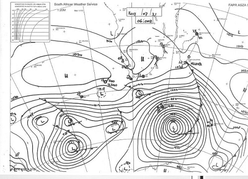
Map: Synoptic map for surface conditions on Friday 21 July 2017 06:00 for southern Africa and the southern seas.
Source: South African Weather Service
High pressure control on the surface and in the alto levels is still the order of the week. A fairly static weather pattern continued for the duration of the week with high pressure cells on either side of the sub-continent, and a relatively strong high also present over a very large area of southern Africa. This is typical for the winter period after the solstice.
As can be seen from the synoptic map, the three highs eventually formed an almost continuous band of high pressure running from deep in the South Atlantic across southern African and deep into the southern Indian Ocean.
A frontal system followed the leading edge of the South Atlantic high but its effect was cushioned by two factors. First, the spread-out high pressure cell effectively acts as a buffer, especially on the surface, preventing the intensely cold air behind the front to reach the mainland. Secondly, and this is the strongest influence, some 2000 km south of the high’s core, another intense vortex formed near 20°S and migrated in sync with the high on the latter’s southern boundary.
These southern vortices are unprecedented for regions outside the polar circle. They form intense depressions with a rapid rotation and a very high vertical velocity. In a sense, they are huge vacuum cleaner that suck the denser air away from the high and transport it into the upper layers of the atmosphere.
The further south one goes, the thinner the atmosphere. From around 56,000 feet at the tropics, the atmosphere fall away in height to a mere 18,000 feet near and in the polar circle. This “thin” atmosphere enhances the effect of the vortex, amplifying its influence on the high to its north. The results is that the high, while still dense and cold, is siphoned away to the south behind the front and it loses much of its ability to have a marked impact further north, i.e. over the southern African sub-continent.
The barometric pressure at the core of the vortex is an unprecedented 948 mB. Similar to the vortex of two weeks ago, it weakened the frontal system which failed to make landfall. While the low pressure systems exaggerate polar winter conditions, its effect further north is to limit frontal activity, leading to a warmer winter in general over the sub-continent.
Surface temperatures in Namibia’s northern half tenaciously remained above 24°C with the areas north, west and east of Etosha going to 30°C or very close, in the late afternoons.
Looking further afield than just local weather phenomena, it is noteworthy that sunspot activity is at its lowest for many decades. This leads to all sorts of fanciful speculation among scientists but it is not an invalid observation that there is a discernible link between solar activity (sunspots and coronal mass ejections), the earth’s magnetosphere and local weather conditions.
What’s Coming
The forward extension of the South Atlantic high remains the dominant feature during the weekend but the 1020 mB isobar reaches north only as far as the Orange river. Its core at a respectable 1024 mB makes landfall in the Western Cape by Saturday evening but a northward intrusion is unlikely.
By Monday the continental high has departed with only a small presence over Lesotho. A frontal system approaches the Cape which again brings windy conditions to Namibia’s south.
By Tuesday the South Atlantic high has intensified to 1028 mB with very cold conditions in the Western and southern Cape. The local impact will reach Namibia only by Wednesday and it will be restricted to the south-western quadrant.
A possibility of frost is forecast for Tuesday night in the Karasburg and Keetmanshoop districts with the cold (but not frost) reaching north along the Botswana border up to the Otjozondjupa Region.


