Understanding Weather – not predicting – 11 May 2012
What happened?
That the changing climate brings a range of varying aspects clustered under the same roof becomes more and more obvious, not only under our section of the roof but on as worldwide scale as one could expect to find.
Varying aspects are occasionally in cohesion but quite frequently at odds. The problem lies in that for all the detail, across the past century or longer, what we have come to understand about weather is founding into history because the weather foundations of today differ markedly from those upon which that earlier understanding was built.
Certain fundamentals cannot change: reaction to daytime heat or night-time cold, volume and depth of moist air inflow for instance, but the further reaction now has other inputs which we are slowly beginning to try and grasp.
The local impact is just as dramatic as the global weather changes. Take for instance the persistent successive flooding in the north or the astonishing rainfall of last year.
This week gave examples of this clash of the old and the new.
As the northern hemisphere summer evolves, so we settle into a compensatory winter pattern. It is expected that a core of high pressure should take control. In one way it has, in another there is a difference.
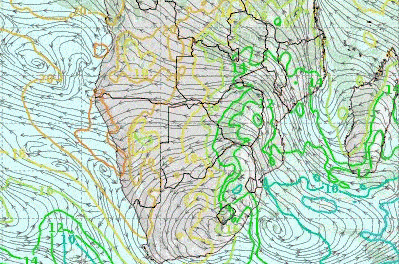
A slow moving anticyclonic core developed over the South Atlantic where it is usually present. Then it slipped past the southern Cape and settled over much of South Africa, Botswana and eastern Namibia, dominating the middle levels from some 12,000ft AMSL deep into the 20,000ft range.
Much further south, over the southern ocean, the anti-cyclonic high created an intense and deep vortex between 35 and 45oS. This is nearly normal, but both intensity and depth (upward extension and very low pressures) deviated from the norm. This vortex also limited the winter rainfall potential which is another deviation from the norm. By this time of the season, the Western Cape must receive its first continuous rainy spells. So far, not much.
The very prominent airflows ahead of the cold fronts that march past the Cape with regular monotony, has for the time being abated. The dominant airflow is from the east. It crossed the continent to reach the Atlantic causing exceptionally high temperature in Walvis Bay and further north.
What’s coming?
The anticyclonic core splits as it drifts to the east enabling limited airflow from the north. Some cloud is expected over central and southern Namibia. There is scant prospect for showers, though.
With anticyclonic control in place, the prospect for berg-wind conditions, “oos weer” intermittently, at least, prevails for much of the coast.
Cold frontal activity barely gets to our extreme south, with limited cold air incursions. Outgoing overnight radiation with colder early mornings, begin to have an effect but frost is unlikely anywhere. Inland, the lower level northerly airflows with pleasant warmth is the daily expectation.