Weather 03 July 2015
 What Happened
When a cold, dense airmass moves horizontally, it tends to descend because of its higher density.
If it is on the surface, it will stay on the surface but its circulation will be extremely slow, again due to its density. When this airmass encounters a lighter, warmer airmass, the cold, dense airmass tends to stay at surface level while the lighter, warmer airmass tends to move both laterally and vertically over the denser, colder airmass. At the interface where these two meet, there is considerable difference in temperature and in barometric pressure. This creates a so-called inversion layer which can be small and localised, or which can be expansive and cover many hundreds of kilometres.
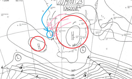
A textbook inversion layer was present over Namibia for most of this week, and it is set to continue into the weekend. The South Atlantic high pressure cell was very strong and dominant for the whole week. The two highs of a week ago have merged while still out at sea and moved closer to the African coastline. Over the previous weekend it made landfall bringing in a very cold conditions. Its presence on the surface was felt as far north as Owamboland, and in the east, up to the Sashi River, the border between Botswana and Zimbabwe.
Above and over it entered a strong anti-cyclonic circulation originating from the warmer, moister climes of the countries north of Namibia. As this layer shifted over the high, the inversion layer formed. It became visible on Monday afternoon at the Angola border and it gradually spread to the south during Tuesday and Wednesday where it created partly cloudy and warmer conditions over the interior plateau. By Thursday it covered almost two thirds of the country. This cloudiness slowly drifted to the south and to the east, eventually moving across Botswana into the South African interior.
In the upper levels where the high and the low pressure systems converged, a prominent convergence line formed. The clash between the two systems caused a very strong zonal flow from west to east, advecting the cloud-bearing inversion layer towards the east and south-east. This happened at around 35,000 feet.
It was again the classic hamburger atmosphere with a high on the surface, up to about 16,000 feet, a low pressure inversion layer above this up to about 30,000 feet, and considerable jetstream activity in the layers above this altitude. At some point on Wednesday evening, these zonal jetstreams were estimated to travel in excess of 200 km/h. It adds considerably to the travelling time of airliners from Johannesburg to Windhoek, and gives a nice boost to those flights going back. The hamburger atmosphere remained very much in place, with the surface high moving across land to cover southern Botswana, most of South Africa, and even Zimbabwe and southern Mozambique. The result were cold nights but no frost, and warm, pleasant days as the sun heated up the cold air. However, when the sun set, the high remained dominant and the cold returned. Meanwhile, in the middle levels, the moisture from the north remained, leading to cloudiness over almost the entire country except the coastal plain.
What’s Coming.
The South Atlantic high pressure cell is displaced slightly southward as it moves over land. It also loses some of its strength receding from 1032 mB while at sea to 1022 mB while over land. Nevertheless, it is still a strong high and as it crosses the continent and reaches the southern Indian Ocean, it gathers some strength again, and really blasts southern Madagascar next week Tuesday night.
Over the continent, conditions remain static on the surface, mobile and moist in the middle layers, with considerable lateral volatility in the upper levels. For Namibia it means a continuation of cold nights but no frost, and warm, pleasant days. Although there are some forecasts that expect light precipitation over the central plateau from Monday onwards, this is not a consensus view. Still, much moisture is present in the upper levels above 22,000 feet so minor miracles may just happen.
The departing high causes a strong south to north airflow into the Mozambican Channel. As this cold air crosses the sub-continent, it enters the anti-cyclonic continental circulation and should reach eastern Namibia from across Botswana around Tuesday night. Gobabis and Buitepos will see a drop in temperature, but only briefly. No frost is expected.


