


Weather 06 February 2015
![]() What Happened
What Happened
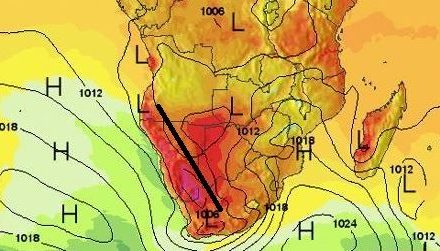
The broad swath of warmer water between South America and Southern Africa warrants attention. In the upper 300 metres of the Atlantic Ocean, water temperature has been rising steadily since the end of November. Borne along by the North South current off the South American coast, it has brought water with a temperature as high as 28oC to as far south as the 25oS latitude. This is more or less in line with Walvis Bay. The sea current then transported this very large patch of warm water across the Atlantic Ocean from the South American coast to the African coast. As the water migrates from west to east, it cools somewhat but remains considerably warmer than usual. The result is a positive temperature anomaly of between 2oC and 3oC. This warmer water in turn leads to a chain of weather reactions, the effect of which we have seen since the end of November and which was particularly pronounced this week. High pressure cells form over cold water where the sea current usually does not exceed 3 knots. This is a clearly demarcated zone circling the entire globe between specific latitudes and it is known as the high pressure belt. It reaches south to about 50oS latitude and north to about 25oS. Between Africa and South America, it is the source of the South Atlantic high pressure cell that form with regular monotony just off the South American coast and then migrates over the next ten days to the African coastline. When it reaches the continent, the land’s heat collapses the high pressure cell but it is displaced slightly southward, and then slips around the continent at Agulhas. When it reaches the eastern side of the continent, it become the engine that drives the circulation that advects moisture from the Indian Ocean across central Africa into Angola, and eventually into Namibia. With the warmer water in the South Atlantic, the high pressure cell has weakened, typically only reaching about 1020mB barometric pressure at its core. But as the cell weakens its outer composition also disperses over a much larger area. Reading about 1016mB, this dispersion of the high pressure cell has been present over the South Atlantic for several months. At the end of December, it reached almost to the equator. In January it pulled back to about the Kunene River mouth, but it has been present all the time. This week, it was again prominent off the Namibian coastline. The high pressure control acts from the south-west, opposing and displacing the expected airflow from the north-east and the north-west. The result is clear skies, little wind, excessive fog at the coast (for summer), unseasonally cold nights and zero rain. This is exactly what happened this week.
What’s Coming
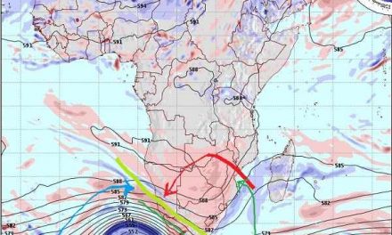
Most of South Africa above the escarpment, Botswana, western Zimbabwe, western Zambia and southern Angola remain firmly in the grip of the high pressure control on the surface. Needless to say, this also includes Namibia. The only expected difference, is that the (weak) core of the South Atlantic high, will move further south than has been the case for the past two months. It is expected to move to the 40oS latitude, more or less in line with Gough Island, before it slips around the continent. A significant feature on the synoptic map is the vortex (strong low pressure area) in the Mozambican Channel. This vortex is expected to increase in intensity, almost to cyclone strength, then migrate southward where it will eventually, by the end of next week, dissipate over cooler water. But while it is present, it will convect massive amounts of moisture into the middle and upper air layers. For us it means better rainfall prospects for the second half of February than for the first half. It is only by Wednesday next week, that a very broad but weak trough forms from Angola across the Namibian interior and into the Northern Cape, but the rainfall expectations are for 1’s and 2’s. High pressure control will remain as long as the sea surface temperature anomaly in the South Atlantic is present.